Mogilev province. Maps of the Mogilev province Map of the Mogilev province in 1800
It was necessary to accurately establish the boundaries of land holdings of both individuals and peasant communities, cities, churches and other possible land owners.
Sample of Babinovichi district
Vitebsk province
Vitebsk district 2 versts
1.2 versts
2 versts
1 mile
2 versts
2 versts
Nevelsky district 2 versts
Polotsk district 2 versts
2 versts
Sebezh district 2 versts
2 versts
Minsk province
2 versts
2 versts
2 versts
2 versts
2 versts
2 versts
2 versts
2 versts
2 versts
2 versts
Mogilev province
Belitsky district 2 versts
2 versts
Klimovichi district 2 versts
Kopys district 2 versts
Mogilev district 2 versts
Mstislavsky district 2 versts
Orsha district 2 versts
Rogachevsky district 2 versts
Sennen district 2 versts
Starobykhovsky district 2 versts
Chaussky district 2 versts
Cherikovsky district 2 versts
3-mile maps of Belarus.
F.F. the scale is three versts, which translated into the modern system of calculations will be 1:126000, that is, 1 cm – 1,260 km. These old ones cards Dating back to the second half of the 19th century, maps were printed starting in 1860. and until the beginning of 1900.
All maps with good detail of objects, showing churches, mills, cemeteries, relief, type of terrain and other objects.

Sample 3 layout
Maps can be downloaded.
Special Map of European Russia.
is a huge cartographic publication, running on 152 pages and covering a little more than half of Europe. Mapping lasted 6 years, from 1865 to 1871. Map scale: 1 inch - 10 versts, 1:420000, which in the metric system is approximately 1 cm - 4.2 km.
Maps can be downloaded.
Maps of the Red Army.
(Workers' and Peasants' Red Army) were compiled and published both in the USSR in the period from 1925 to 1941, and in Germany, in preparation for the war, in the period 1935-41. On maps printed in Germany, the name in German is often printed next to the Russian name of a village, river, etc.
250 meters.


Poland 1:25 000
500 meters.

kilometres.

Maps can be downloaded.
Polish WIG cards.
Maps were published in pre-war Poland - Military Institute of Geography (Wojskowy Instytut Geograficzny), the scale of these maps is 1:100000 and 1:25000 or, to put it simply, 1 cm - 1 km and 1 cm -250 m, the quality of the maps is very good - 600 dpi, respectively, and the size of the maps is also not small, in fact, everything is more than 10 megabyte.
Intelligent, detailed and search engine-friendly maps. All the smallest details are visible: farmsteads, dungeons, farmsteads, manors, taverns, chapels, mills, etc.
Kilometer.

sample WIG card.
250 meter

One-verst map of Belarus.
A one-verst map of the western border area on a scale of 1-verst per inch (1:42000) was published from the 1880s until the First World War, and was republished until the end of the 1930s.
Maps at a scale of 1:42000.

Military topographical 2-mile map of the Western Border Space.
Maps at a scale of 1:84000 (two-layer). Two-mile maps of the western border area began to be printed in 1883. The maps were also basic topographic maps during the First World War in the Russian army.

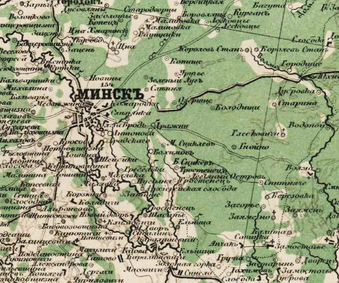
Old maps of Mogilev province
The Mogilev province, one of the six provinces of the North-Western region of the Russian Empire, was formed in 1772 as a result of the 1st partition of the Polish-Lithuanian Commonwealth and the inclusion of part of its Belarusian lands into the Russian Empire (the northern part of these lands was included in the Pskov province) . Under the conditions of the existence of the institution of provinces, during the first few years, the Mogilev province was divided into 4 provinces - Mogilev, Mstislavl, Orsha and Rogachev. After the abolition of the administrative-territorial division of the provinces of the Russian Empire into provinces (1775), in 1777 the Mogilev province was divided into 12 districts. As a result of the administrative reform of Catherine the Second in 1778, the Mogilev province was transformed into the governorship of the same name. During the territorial transformations of Paul the First in 1796, the Mogilev governorship was transformed into the Belarusian province of 16 counties.
In the Mogilev province in whole or in part
There are the following maps and sources: Five-verstka of the Mogilev province Five-verstka of the Mogilev province 1910.
Topographic map indicating longitudes and latitudes on a scale of 1cm = 2000m. This card was cut into pieces (rectangular sheets) and has a prefabricated sheet. Color maps, very detailed, from the Austro-Hungarian atlas of 1910. (therefore, all names of settlements are indicated in Latin).
The Mogilev province bordered on the following provinces: Vitebsk province, Smolensk province, Chernigov province, and Minsk province.
Under Alexander the First, in 1802, the Belarusian province was again renamed Mogilev, and the district “grid” of the new province was reduced to the previous 12 districts - Babinovichsky (abolished in 1840)
1840 Babinovichi district is abolished. Its territory is part of the Orsha district of the Mogilev province.
Map of the administrative division of the Orsha district of the Mogilev province into volosts, the beginning of the 20th century
Belitsky (in 1852 renamed Gomelsky), Klimovichsky, Kopyssky (in 1861 renamed Goretsky), Mogilevsky, Mstislavsky, Orsha, Rogachevsky, Sennensky, Starobykhovsky (renamed Bykhovsky in 1852), Chaussky, Cherikovsky. Thus, during the entire subsequent pre-revolutionary period of the Mogilev province’s existence, it consisted of 11 districts, of which Ragachevsky was the largest, and Chaussky the smallest. The administrative center of the province was the medieval city of Mogilev, the first mention of which in chronicles dates back to 1267.
1917 Western Region formed

1918 (October 13). The Western Region was transformed into the Western Commune.
1918 (December 31). The Belarusian Soviet Socialist Republic was proclaimed in Smolensk. It includes the territories of Minsk, Grodno, Mogilev, Vitebsk and Smolensk provinces.


1919 (May 25). The Mogilev province was abolished. Its territory, including the Orsha, Goretsky, Mstislavl and Klimovichi districts bordering the Smolensk region, was transferred to the newly formed Gomel province.
1919 (June 30). The Mikulinskaya, Rudnyanskaya, Lyubavichskaya and Khlystovskaya volosts of the Orsha district, part of the Goretsk district and almost the entire Mstislavl district of the Gomel province were annexed to the Smolensk province.

All these redistributions created an incredible confusion in the names - suffice it to mention that in the complete collected works of Lenin for 1919 there is such a name: “ Rudnyansky executive committee of the Mikulin volost of the Orsha district of the Mogilev province»

1924 (March 3). From the Smolensk province, the entire Goretsky district, Shamovskaya, Staroselskaya, Kazimirovo-Slobodskaya, parts of the Bokhotskaya, Oslyanskaya and Soinskaya volosts of the Mstislavl district with the city of Mstislavl were transferred to the BSSR. The remaining volosts of the Mstislavl district in the Smolensk region entered the Smolensk district, and parts of Oslyanskaya and Soinskaya - into the Roslavl district.
1929 (October 1). The Western Region was formed with its center in the city of Smolensk. It included the territories of Smolensk, Bryansk, parts of Kaluga, Tver and Moscow provinces, Velikoluzhsky district of the Leningrad region.

The western region is divided into eight districts with 125 districts. The districts are divided into village councils. The old administrative-territorial system: province - district - volost - has since ceased to exist.
The Lyubavich volost, having received the status of a village council, became part of the Rudnyansky district, formed on the territory of the former Orsha and Smolensk districts.

1937 (September 27) The Smolensk region was created on the territory of the Western region.
Borders of the Rudnyansky district and the Smolensk region in 1957:


The current configuration of the Rudnyansky district, which shares Ponizovye with the Demidovsky district:

The Mogilev province was founded on May 28, 1773 from part of the Belarusian lands that passed to Russia under the first partition of Poland (P.S.Z. 13.807 and 13.808). On January 10, 1778, it was transformed into a viceroyalty (P.S.Z. 14.691); On June 17 of the same year, public places were opened (P.S.Z. 14.774). On December 12, 1796, the governorship was united with the Polotsk province under the name of the Belarusian province, and Vitebsk was appointed as the provincial city (P.S.Z. 17.634). By decree of February 27, 1802, the Belarusian province was divided into two independent provinces - Mogilev and Belarusian-Vitebsk (P.S.Z. 20.162). In the same year, a provincial government was established. In 1802–1856 as part of the Vitebsk General Government. At the beginning of the twentieth century, it consisted of 11 counties and 144 volosts; the province had 13 cities and 8,392 other settlements.
Governor
Kakhovsky Mikhail Vasilievich, general-m. 1773 – 1778
Viceroyal Rulers
Kakhovsky Mikhail Vasilievich, general-m. 1778 – 1779
Passek Petr Bogdanovich, por. 1779 – 1781
Engelhardt Nikolai Bogdanovich, s.s. (d.s.s.) 1781 – 1790
Vyazmitinov Sergey Kuzmich, general-m. 1791 – 1794
Cheremisinov Gerasim Ivanovich, D.S.S. 1794 – 1796
Dec. 1796 – Feb. 1802 – as part of the Belarusian province
Governors
Bakunin Mikhail Mikhailovich, t.s. 1802 – 1809
Berg Petr Ivanovich, D.S.S. 1809 – 1811
Tolstoy gr. Dmitry Alexandrovich, D.S.S. 1812 – 1820
Meller-Zakomelsky Fedor Ivanovich, s.s. 1820 – 1822
Velsovsky Ivan Danilovich, s.s. 1822 – 1824
Maksimov Ivan Fedorovich, s.s. 1824 – May 21, 1828
Muravyov Mikhail Nikolaevich, s.s. 15 Sep. 1828 – 24 Aug. 1831
Bazhanov Georgy Ilyich, s.s. (d.s.s.) Aug 24 1831 – June 2, 1837
Markov Ivan Vasilievich, D.S.S. June 2, 1837 – January 26 1839
Engelhardt Sergey Pavlovich, s.s. 26 Jan 1839 – March 2 1844
Gamaleya Mikhail Mikhailovich, s.s. (d.s.s.) Apr 10 1845 – 11 Sep. 1854
Skalon Nikolay Aleksandrovich, s.s. (d.s.s.) Sep 11 1854 – 2 Nov. 1857
Beklemishev Alexander Petrovich, s.s., i.d. (approved with production in D.S.S. December 31, 1856) November 22. 1857 – May 17, 1868
Shelgunov Pavel Nikanorovich, general-m. May 19, 1868 – Oct 12 1870
Dunin-Barkovsky Vasily Dmitrievich, D.S.S. Oct 16 1870 – March 30 1872
Dembovetskoy Alexander Stanislavovich, sound. chamberlain, d.s.s. (t.s.) March 30 1872 – Aug 30 1893
Martynov Dmitry Nikolaevich, D.S.S. Aug 30 1893 – 23 Dec. 1893
Zinoviev Nikolay Alekseevich, t.s. 23 Dec 1893 – February 8 1901
Semakin Mikhail Konstantinovich, general-m. 18 Feb 1901 – May 17, 1902
Klingenberg Nikolay Mikhailovich, D.S.S. July 1, 1902
Counties of Mogilev province
Mogilev district
Bykhovsky district
Gomel district
Goretsky district
Klimovichi district
Mstislavsky district
Orsha district
Rogachevsky district
Sennen district
Chaussky district
Cherikovsky district
In 1777, the Mogilev province was divided into 12 districts. In 1778, the province was renamed the Mogilev governorship, which was abolished in 1796, and the counties became part of the Belarusian province. In 1802, the Mogilev province was restored as part of the previous 12 counties.
Since September 1917, the province was assigned to the Western Region, in 1918 to the Western Commune, from January 1919 to the BSSR, and from February to the RSFSR. On July 11, 1919, the Mogilev province was abolished, 9 of its districts became part of the Gomel province, the Mstislavsky district was transferred to the Smolensk province, and the Sennen district was transferred to the Vitebsk province.
In 1938, the Mogilev region was formed with its center in Mogilev.
Initially, the Mogilev province included 12 districts: Babinovichsky (be) (abolished in 1840), Belitsky district (renamed Gomel in 1852), Klimovichsky, Kopyssky district (renamed Goretsky in 1861), Mogilevsky, Mstislavsky, Orsha, Rogachevsky, Sennensky , Starobykhovsky district (in 1852 renamed Bykhovsky), Chaussky, Cherikovsky.
At the end of the 19th and beginning of the 20th centuries, the province included 11 districts.
With the introduction of zemstvo institutions in 1864, the province was left unzemskiy. In 1903, the “Regulations on the management of zemstvo economy in the provinces of Vitebsk, Volyn, Kiev, Minsk, Mogilev, Podolsk” was adopted, according to which a modified order of zemstvo management was introduced in the province, with the appointment of all members of zemstvo councils and zemstvo councilors from the government. This procedure was considered unsuccessful, after which, in 1910, a bill was developed on the introduction of elected zemstvo institutions in these provinces, but also with exceptions from the general procedure aimed at excluding Polish landowners from participation in zemstvos. The adoption of this law in 1911 was accompanied by an acute political crisis (see Law on Zemstvo in the Western Provinces). Elected zemstvos in these six provinces have operated since 1912.
Occupation bond for the province, 1918.
[IMG]
CITY OF SMUGGERS
Frontier life
Before the new border had time to clearly and firmly divide the old native Russian lands, stormy border life with all its typical manifestations began to boil in the fresh border strip that replaced the melted front.
- Smuggling, “agents”, “processing” of border guards and speculation, speculation, speculation without measure and end.
Border town of Orsha.
Just recently it was a quiet, dirty provincial town, no different from other district “towns” of the Mogilev province. Most of its inhabitants, it seems, were only engaged in borrowing from each other “for the holiday” or conducting small, most primitive trade with the village.
And now?
Now Orsha “supplies” fabrics, soap, knitwear to Minsk, Vilna, Warsaw and almost Vienna and Berlin and vice versa - Smolensk, Moscow and Petrograd, chemical industry products, saccharin.
Orsha “sets the tone.” Orsha dictates prices.
And even if there is no sign of a Russian-German or Russian-Austrian treaty yet, local trade “fraternization” has already begun and is successfully developing widely:
- Smuggling.
Everyone here is involved in smuggling, from the Germans and our “border guards” to visiting men, who also often come across “piles” of “sweet” (saccharin), “bitter” (caffeine), “colored” (aniline dyes) and “hard” "(flints for lighters).
Orsha "exchange"
Carrying goods across the border in one direction or another, as well as their further transport in constantly inspected trains, is associated with great risk, and merchants coming to Orsha, both from Russia and from the occupied regions, prefer to resell goods to clever “dared souls” who “cross” the border "or desperate speculators heading to Moscow.
Thus, an improvised “exchange” is being created in Orsha, which, no worse than the London and New York exchanges, dictates prices to world markets.
For example, ladies' stockings come here, listed in Moscow for 180-200 rubles a dozen: and the Orsha "exchange" sets the price for them at 300-350 rubles, and with a further "legal" increase they are sold in Minsk for 500 or more rubles per a dozen.
But a particularly wild bacchanalia took place at one time at the Orsha “exchange” with German saccharin (Susstoff) and Austrian flints for lighters. The prices for these goods have risen so much compared to those existing in Minsk that almost all Minsk residents, people of the most diverse professions and social statuses, have engaged in profitable transport of saccharin and flints to Orsha.
And the stock exchange madness began!
It’s easy to imagine what was happening in Moscow at that time with these goods:
- 5000-6000 rub. per kilo.
But then something happened that should have inevitably happened due to iron economic laws. Depletion of the Minsk market and saturation of the Moscow market.
Prices rise in Minsk and fall in Moscow.
And the reverse movement began. The Orsha “stock exchange” was busy again.
The same thing with Ukrainian and Polish sugar. Its price in Minsk is 5 rubles. per pound, and it’s clear why in Moscow it reaches 25-30 rubles. per pound.
"Agents"
Before you have time to get out of the car, tightly packed with people and littered from top to bottom with bundles, bags, baskets and boxes, you are “met” by a smart guy, definitely your compatriot, depending on your nationality:
Pole, Latvian, Jew, Armenian...
- Are you a “leftist”? - the unexpected question in a low voice stuns you.
You, of course, assume that this refers to your political beliefs and throw up your hands in bewilderment:
- What do beliefs have to do with it?..
But what follows is said almost in a whisper: “You don’t have a pass?.. Don’t worry, I’m mine - I’ll arrange everything.” He explains everything to you right away.
Since at present, obtaining a pass to the occupied places presents insurmountable difficulties and is associated with endless red tape, it is quite understandable that in most cases you answer in the affirmative and dutifully follow your unexpected “benefactor”, who, having left the station with you, is here and in some special, as if learned, obviously professional, patter he verbally outlines to you his “price list”:
- Without things 200, with things 300, with goods 100 poods, with money 10 per ruble.
Before you:
- "Agent"
"Tse-Ka" smuggling
If you agree, the “agent” will take you through some dirty streets, and you will find yourself through the vast gates of some ancient building, obviously a former Jesuit monastery, and through a vast, but grassy courtyard and some kind of gate in a stone overgrown dark - green moss wall - into another courtyard, where in one of the buildings there is a lively zucchini, where you can get various “foreign” snacks and even cognac.
Here you meet the most varied crowd: refugees, speculators, “agents”, and border guard soldiers, both ours and Germany. Various transactions are made here. The guard schedules of our and the German cordons are known here. Here you are introduced to the “guides” and “your” sentries. Here carts are hired and capital is “provided.” In one word here:
- “Tse-Ka” smuggling.
Crossing the border
Having visited this or another similar “Tse-Ka” and “secured” the money, if you have any, that is, insured it with one of the “respected in the city” persons, and also secured the necessary “personal acquaintance”, you calmly and cross the border quite safely, sometimes even as if quite legally, and your documents are checked, your things are looked through and everything turns out to be:
"In order".
And then you are handed over to “your” sentry behind the cordon, who provides you with peace of mind already in the occupied territory.
("V. M.")
Maps are available for free download
Maps are not available for free download, to receive maps - write to mail or ICQ
Historical information on the province
Mogilev province is an administrative-territorial unit in the north-west of the Russian Empire.
It was formed in 1772 after the first partition of the Polish-Lithuanian Commonwealth from part of the Belarusian territories that went to Russia (the northern part became part of the Pskov province). Initially, the Mogilev province included the Mogilev, Mstislavl, Orsha and Rogachev provinces.
In 1777, the Mogilev province was divided into 12 districts. In 1778, the province was renamed the Mogilev governorship, which was abolished in 1796, and the counties became part of the Belarusian province. In 1802, the Mogilev province was restored as part of the previous 12 counties.
Since September 1917, the province was assigned to the Western Region, in 1918 to the Western Commune, from January 1919 to the BSSR, and from February to the RSFSR. On July 11, 1919, the Mogilev province was abolished, 9 of its districts became part of the Gomel province, the Mstislavsky district was transferred to the Smolensk province, and the Sennen district was transferred to the Vitebsk province.
In 1938, the Mogilev region was formed with its center in Mogilev.
Initially, the Mogilev province included 12 counties: Babinovichsky (abolished in 1840), Belitsky district (in 1852 renamed Gomel), Klimovichsky, Kopyssky district (renamed Goretsky in 1861), Mogilevsky, Mstislavsky, Orsha, Rogachevsky, Sennensky, Starobykhovsky district (in 1852 renamed Bykhovsky), Chaussky, Cherikovsky.
At the end of the 19th - beginning of the 20th centuries, the province included 11 districts:
No. District District city Area, verst² Population (1897), people.
1 Bykhovsky Bykhov (6,381 people) 4,105.8 124,820
2 Gomel Gomel (36,775 people) 4,719.4 224,723
3 Goretsky Gorki (6,735 people) 2,487.0 122,559
4 Klimovichi Klimovichi (4,714 people) 3,711.4 143,287
5 Mogilevsky Mogilev (43,119 people) 3,009.9 155,740
6 Mstislavsky Mstislavl (8,514 people) 2,220.4 103,300
7 Orsha Orsha (13,061 people) 4,813.9 187,068
8 Rogachevsky Rogachev (9,038 people) 6,546.1 224,652
9 Sennensky Senno (4,100 people) 4,268.8 161,652
10 Chaussky Chausy (4,960 people) 2,168.0 88,686
11 Cherikovsky Cherikov (5,249 people) 4,083.9 150,277
* All materials presented for downloading on the site are obtained from the Internet, so the author is not responsible for errors or inaccuracies that may be found in the published materials. If you are the copyright holder of any material presented and do not want a link to it to be in our catalog, please contact us and we will immediately remove it.
Mogilev province existed in 1772-1919. The administrative center was the city of Mogilev. The province was created after the 1st partition of the Polish-Lithuanian Commonwealth in 1772 from the lands of the former Mstislavl, Vitebsk and Minsk voivodeships of the Grand Duchy of Lithuania, annexed to the Russian Empire. Included Orsha, Mogilev, Mstislav and Rogachev provinces. In 1777 the province was divided into 12 districts: Orshansky, Babinovichsky, Belitsky, Klimovichsky, Kopyssky, Mogilevsky, Mstislavsky, Rogachevsky, Sennensky, Starobykhovsky, Chaussky And Cherikovsky. In 1778 it was renamed Mogilev governorship, which was abolished in 1796, and the counties became part of the Belarusian province with its center in Vitebsk. Old maps of the Mogilev province show divisions into counties in different years of the 19th century.
The Mogilev province was restored in 1802 as part of the former 12 counties, divided into 39 camps and 147 volosts. It bordered in the west with the Minsk province, in the east with Smolensk, in the south with Chernigov, and in the north with Vitebsk province. In 1840, Babinovichi district was abolished and annexed to Orsha, in 1852 Belitsky district was renamed Gomel district, Starobykhovsky in Bykhovsky. In 1861, Kopyssky district was abolished, and its territory was divided between Sennensky, Orsha and newly created districts Goretsky, which also included part of the Orsha district. Since September 1917, the Mogilev province, as part of the Western Region, was part of the BPR, proclaimed in March 1918, since January 1919 in the BSSR, since February in the RSFSR. 11.7.1919 Mogilev province was abolished, 9 of its districts were included in the newly formed Gomel province, Mstislavsky district was transferred to Smolensk, and Sennensky - to Vitebsk province.
Population of Mogilev province
In 1865, by royal decrees, 37.7 thousand small Belarusian gentry of the Mogilev province, the so-called. odnodvortsy were registered in the peasant class. The former gentry was divided into 2 groups: the eastern, which mainly included the Orthodox gentry (19.5 thousand Orthodox and 6 thousand Catholics who settled above the Sozh), and the western, Catholic (10.5 thousand Catholics and 1.7 thousand Orthodox, who settled above the Drut River).
According to the 1897 census, the population of the Mogilev province was 1,686,700 thousand people. According to class: nobles - 27.7 thousand, clergy - 6.4 thousand, merchants - 3.5 thousand, burghers - 291.8 thousand, peasants - 1351.5 thousand. According to religion: Orthodox - 1402.2 thousand, Old Believers - 23.3 thousand, Catholics - 50.1 thousand, Protestants - 6.9 thousand, Jews - 203.9 thousand, Muslims - 184 people. The literate population in the Mogilev province was 16.9%, in the cities - 45%. In 1884 - 2 gymnasiums, 2 pro-gymnasiums, an agricultural and vocational school in Gorki, and a railway school in Gomel.
The province was part of the Mogilev Orthodox and Mogilev Catholic dioceses. At the end of the 19th century, there were 804 Orthodox churches, 6 male and 5 female monasteries, 30 churches, 340 synagogues and Jewish houses of worship, 2 Lutheran churches, 29 Edinoverie churches and Old Believer prayer houses.
At the end of the 19th century, the Moscow-Brest, Libavo-Romenskaya, Oryol-Vitebsk, Gomel-Bryansk railways passed through the territory of the Mogilev province, distilleries predominated, and peasants were engaged in handicrafts.
Messages:
2019-12-26 Ekaterina Bykhov, city (Bykhov district)
Hello. I am looking for information about my great-grandfather, Lysukha Kirill. he lived with his wife Anna (Grigorievna?) in the city of Bykhov, Mogilev region. they definitely had children Boris (possibly spelled Borislav), Lyuba and another brother for sure. I know that in 1937-38, Kirill’s organs were taken to Moscow as a result of a denunciation, and he died in prison. that's all that is known about him. Kirill's wife subsequently lived in Grodno, and was buried there.... > > >
2019-12-25 Oksana Mstislavl, city (Mstislavsky district)
I'm looking for all the information on my ancestors,
grandfather Artem Mitrofanovich Ivanov, born in 1913, a native of the village of Rakshino or Selets, Mstislavsky district, Mogilev region, and my grandmother Ivanova Maria (I don’t know anything else about my grandmother). My grandparents lived in the village of Chernousy, Mogilev region, my grandfather was the chairman of a collective farm and the director of a local school. . They had three children Zhanna (my mother born in 1936), Valery (brother) and Svetlana (sister). I will be glad for any information. Thank you in advance. ... > > >
2019-12-23 Vadim Korotkov Ozerany, village (Rogachevsky district)
I, Korotkov Vadim Aleksandrovich, am looking for information about my father, Sidorenko Alexander Andreevich and his parents. He was born in 1934 in the village of Ozerany. In his birth certificate, his parents record Andrei Illarionovich Sidorenko, who was shot in the fall of 1941 (as a partisan) and Praskovya Maksimovna Sidorenko, who died before the Second World War.... > > >
2019-12-21 ALEXANDER SIDORENKO
> > >
2019-12-20 ALEXANDER SIDORENKO Krasny Bereg, village (Bykhovsky district)
I'm looking for information about my father Vasily Yakovlevich Sidorenko, born in 1926. Lived in the Mogilev region, Bykovsky district, Krasny Bereg village, his mother Zinaida Ivanovna Sidorenko. Divorced in 1973. Went to his mother. I'm looking for information about him, or his children, if any, I 57 years old. he fought, had a medal for courage (request from the archive), got divorced, I was 11 years old, lived in the village of Efimovsky in the Leningrad region.... > > >
2019-12-19 Yausheva Svetlana Shavkovo, village (Orsha district)
Hello. How can I view the parish books of Shavkovo? I'm interested in my ancestors. Migrants from those places to the Krasnoyarsk Territory. Surname Shabas (Shabus, Shabasovs, Shabusovs).... > > >
2019-12-18 Arkady Polityko Lyutie, village (Sennen district)
I am looking for relatives of my grandfather, Anton Lukyanovich Polityko, born in 1882, who lived in the village. Fierce in 1902.... > > >
2019-12-18 Sidorenko Alexander Vasilievich Krasny Bereg, village (Bykhovsky district)
I'm looking for information about my father Vasily Yakovlevich Sidorenko, born in 1926. Lived in the Mogilev region, Bykovsky district, Krasny Bereg village, his mother Zinaida Ivanovna Sidorenko. Divorced in 1973. Went to his mother. I'm looking for information about him, or his children, if any, I 57 years old. he fought, had a medal for courage (request from the archive), got divorced, I was 11 years old, lived in the village of Efimovsky in the Leningrad region.... > > >
2019-12-17 Irina Tulupova Vezhki, village (Goretsky district)
Village of Vezhki. Surnames Vishnyakov and Zyuzkov
[email protected]... > > >
2019-12-17 Julia Stepsone Solovyevo, village (Orsha district)
I am looking for relatives of Vladimir Karlovich Stepson, born in 1916. He died of his wounds in 1943 in hospital. Before the war, he lived in the village of Solovyovo, Liozno district, Vitebsk region. I would be glad for any information... > > >
 Decembrist uprising The reasons for this were
 Maps of the Pskov province Maps of the Pskov province 1777 1917
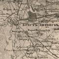 Maps of the Mogilev province Map of the Mogilev province in 1800