Slavyansk and Kramatorsk on old maps - Dead Journal - LiveJournal. Odessa region old photos Maps of Kherson province
And the German versions of 1737.

1736 in German, many points on the Donets are noted
French map of the Seversky Donets basin, 1738. To the south of Tor and Yampol, the Ostraya Mogila and Shchurovka mountains, which are not later found on maps and it is not clear what heights they name, although the toponyms are still alive.
1745. Voronezh province
two versions of the Bosquet map of 1751,
the Turkish border of 1711 is indicated, the word "lines" means settlement of the Ukrainian line, near Bakhmut the settlement of Slaveno-Serbia begins
map of Bosquet, 1754
plan of the Catherine Province from the Dnieper to the Donets, indicating the towns, settlements and farmsteads of the Ukrainian line, 1765
also 1765, but the plan Bakhmut city district with settlements of hussar companies
1782, Azov province, the border between Tor and Bakhmut districts runs along Belyanka and Torets
land map of part of the Izyum district of the Kharkov province, 1784
map 1792 compiled by Wilbrecht at the Mining School. Ekaterinoslav governorship. Look - Donetsk. This is the very first of three cities with this name. What is it called now?

“table-sheet” map of 1816. Churches in Belyansky (now the lower part of Oktyabrsky and Ivanovka) and Shabelkovka
maps of 1821 Kharkov and Ekaterinoslav provinces, ed. Pyadysheva. the territory of Kramatorsk on the very border with Yekaterinoslavskaya
1830, Sloboda-Ukrainian province
Schubert's ten-verst, 1842
three-verst Schubert 1861 or 1863
it seems like the exact same map, but clearer and with some geology
map of Strelbitsky in 1868 with the approximate route of the Kursk-Kharkov-Azov railway under construction.

postal map of the Russian Empire 1871 ed. Ilyina. Two Slavyansk: city and station

a map of mineral resources of Bakhmut district 1902 (according to another data from 1889) indicates the presence of coal near Kramatorsk
1903, visible is the railway line built in 1894 from Slavyansk to the station. Rapnaya

edition of Schubert's three-versat version 1896, but without the branch to Rapna
1909, Marx's World Desk Atlas, 2nd edition (1910). For example, in this fragment there is New York.
three-verstovka Schubert 1919. The North Donetsk Railway appeared (1910-1911). The second station Kramatorskaya is the current Shpichkino, the final station of the Severodonetsk railway branch. from Liman station, while the first Kramatorskaya station belongs to the Southern Railway. The Slavic city line is marked with a thin, inconspicuous line, probably because it was not part of the large railways.
Publication 1920. By the way, the meridians on Russian maps are counted from Pulkovo and sometimes additionally from Paris.
two Ukrainian maps from 1918
1928, Artyomovsky district
Belenkaya (town since 1938) and Druzhkovka (city since 1938) are still fragmented into a bunch of small villages. The actively developed part of Slavyansk to the north of the station was called Novo-Slavyansk. Many colonies and artels. Small red circles are village councils, small squares are village councils, large circles are district councils, a large square is a city.

American map 1943 edition based on materials from Soviet maps 1938. marked New Slavic
topographic map 1939 with a diagram of the offensive of the 57th and 37th armies, January 1942

“Map of the Red Army” 1:500,000, 1941
aerial photography of Slavyansk and Kramatorsk August 1941
German map 1943, sheet Makeevka. Here on the Slavic city railway even the stations are marked. The railway south of what was then Sotsgorod was temporary for the supply of building materials and was dismantled after the war.
Scheme of the South Donetsk Railway 1943 (the road existed in 1937-1953). For some reason, the Slavic city railway ends at Rapnoy, but the current stop has a pleasant name. Observatory - Colonial (it is hardly noticeable on other maps).
map from znich.org.ua
1942. Didn't find New York? Here it is also there, and more noticeable.
1943, American map of the European part of the USSR. The leaf is called Konstantinovka, because before the war it was larger than Kramatorsk.

map of the USSR 1944 (published 1946). nothing special except Bylbasovka (until 1964 it was officially mistakenly called Belbasovka) in place of Cherevkovka and Krasnogorka instead of Krasnotorka

1952, Sotsgorod is marked as a populated area Sotsgorodok. In addition, Sotsgorodok is noted near Kurakhovo, but rightly so - in 1958 it was renamed the city of Gornyak.
1980, American aeronautical map, again the sheet is called Konstantinovka. All heights are in feet. High-altitude obstacles are labeled selectively, in the Kramatorsk plant area a pipe of only 225 feet (~70 m, the highest there is 150) is marked, in the Slavyanskaya GRES - 250 feet (probably not converted from meters), but the mysterious 400-foot (~120 m) is confusing ) mast at Slavkurort. The Slavic city railway is still drawn, although it was significantly opened before 1970. And in general, the map does not inspire confidence, look, for example, at Stantsiya Brosino(right Brusin).

1985. Since then, noticeable changes have occurred for such a scale:
1. the cemetery at KIM has expanded
2. several old blocks on Petrovka were demolished and an unfinished boiler house was built
3. the railway line to the ocher mine has been dismantled
4. The railway line along the Kutovaya beam has been dismantled
5. a new district “Azure” (“Chernobyl”) and a road to it were built
6. private development was transferred to the Belenkovsky village council (these blocks should now be black)
7. a railway line and a bridge to the LiP plant were built
8. The cable car from Raigorodok to Khimprom has been dismantled
9. a road bridge across the Donets was built
10. The line to Rapnaya station was dismantled in the 1990s, the station itself is no longer even on this map
11. Mashchermet station in 2012 was renamed after A. M. Kozhushko
12. o. Sobolevka village was renamed Raigorodok
13. The earthen dam has been completed and the reservoir has been filled.
14. The TV tower on Karachun Mountain was destroyed by separatists in 2014. And its height is not 180 m at all
Aerial photo from the late 1980s/early 1990s.
Current Music: Placebo - Slave to the wages
Dear visitors of EtoRetro.ru, you have a collection old photographs of the city of Odessa region? Join us, publish your photos, rate and comment on the photos of other participants. If you recognize a place in an old photograph, an address, or recognize the people in the photo, please provide this information in the comments. Project participants, as well as ordinary visitors, will be grateful to you.
Our members have the opportunity to download old photographs in original quality (large size) without the project logo.
What is retro photography, or how old should it be?
What can be considered an old photograph worthy of publication on our project? These are absolutely any photos, starting from the invention of photography (the history of photography begins in 1839) and ending with the end of the last century, everything that is now considered history. And to be specific, this is:
- photographs of the Odessa region of the mid and late 19th century (usually the 1870s, 1880s, 1890s) - the so-called. very old photographs (you can also call them antique);
- Soviet photography (photos from the 20s, 30s, 40s, 50s, 60s, 70s, 80s, early 90s);
- pre-revolutionary photography, Odessa region (before 1917);
- military retro photographs - or photos from war times - this includes the First World War (1914-1918), the Civil War (1917-1922/1923), the Second World War (1939-1945) or in relation to our Motherland - the Great Patriotic War (1941-1945) , or WWII;
What should be captured in the photo?
Anything, be it streets, buildings, houses, squares, bridges and other architectural structures. This could be another type of transport of the past, from carts. These are the people (men, women and children) who lived during those times (including old family photographs). All this is of value and great interest to EtoRetro.ru visitors.
Collages, vintage postcards, posters, vintage maps?
We also welcome both series of photographs (using the ability to upload several photographs in one publication) and collages (an elaborate combination of different photographs, usually of the same place using some kind of graphic editor) - of the type - was/has become, one way or another immersing you in a kind of time travel, reflecting a look into the past. Also a place on the project and
Maps of Kherson province
| Name | Example | Download | |||
| PGM Alexandria district | 2v | 1828 | 29.1mb | ||
| PGM Elisavetgrad district | 2v | 1828 | 49.7mb | ||
| PGM Olviopolsky district | 2v | 1828 | 82.2mb | ||
| Lists of populated places | 1859 | 224.3mb | |||
| Schubert map | 3v | 1880 |
Maps are available for free download *
Maps are not available for free download, to receive maps - write to mail or ICQ
Historical information on the province
Kherson province- a province that was located in Novorossiya and covered modern Kherson, Nikolaev, part of Odessa and Kirovograd regions.
The province was founded in 1803 by Alexander I by decree of May 15 No. 20760, when the center was transferred from Nikolaev to Kherson. The province existed until 1922, then part of it became Nikolaevskaya.
U By the order of the Senate on October 8, 1802, the Novorossiysk province was divided into Ekaterinoslav, Nikolaev and Tauride provinces. Kherson district became part of the Nikolaev province. The Nikolaev province existed for less than a year. By decree of the Senate of May 15, 1803, the provincial administration from Nikolaev was transferred to Kherson and the province began to be called Kherson. Until the end of the 19th century, there were no significant administrative and territorial changes in the Kherson region. In March 1918, three northern districts, including Dnieper, moved from Crimea to Ukraine; it became an integral part of the Kherson province. On January 28, 1920, the All-Ukrainian Revolutionary Committee adopted a resolution on the division of the Kherson province into Kherson and Odessa. Nikolaev became the center of the Kherson province. In December 1920, the Kherson province was renamed Nikolaev province. Kherson became the district center of the Nikolaev province. In 1922, Odessa and Nikolaev provinces were united into Odessa province. Kherson district has since been part of the Odessa province. In 1923, the Odessa province was divided into 6 districts, including the Kherson district with its center in the city of Kherson. In 1930, a new administrative-territorial reform was carried out. The Kherson district was liquidated, and the Kherson rural district was transferred to the department of the Kherson City Council of Workers' Deputies. In September 1937, Nikolaev region was separated from the Odessa region.
Administrative division
Initially, the province was divided into 4 districts: Elisavetgrad, Tiraspol, Olviopol and Kherson, and from July 1806 into 5: Alexandria, Elisavetgrad, Olviopol, Tiraspol and Kherson. In 1825, the Odessa district was created from parts of the Kherson and Tiraspol districts. In 1828, Olviopol and Elisavetgrad districts were abolished and Bobrinetsky district was created on their basis. In 1834, Tiraspol district was divided into 2 parts and a new Ananyevsky district was created. In 1865, the administration of the Bobrinetsky district was moved to Elisavetgrad and the district was renamed Elisavetgradsky.
* All materials presented for downloading on the site are obtained from the Internet, so the author is not responsible for errors or inaccuracies that may be found in the published materials. If you are the copyright holder of any material presented and do not want a link to it to be in our catalog, please contact us and we will immediately remove it.
 Highly dispersed systems (true solutions) All substances are soluble in water
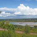 Population of the Altai Territory
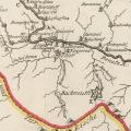 Odessa region old photos Maps of Kherson province