Where is the relief. Reading topographic maps
Hello dear readers! Today I would like to talk about what are the main landforms. So let's get started?
Relief(French relief, from Latin relevo - I raise) is a set of uneven land, the bottom of the seas and oceans, different in contour, size, origin, age and history of development.
Consists of positive (convex) and negative (concave) shapes. The relief is formed mainly due to the long-term simultaneous influence of endogenous (internal) and exogenous (external) processes on the earth's surface.
The basic structure of the earth's relief is created by forces that lurk deep in the bowels of the Earth. From day to day, external processes act on it, relentlessly modifying it, cutting through deep valleys and smoothing mountains.
Geomorphology - it is the science of changes in the earth's relief. Geologists know that the old epithet "eternal mountains" is far from the truth.
Mountains (you can learn more about mountains and their types) are not eternal at all, even though the geological time of their formation and destruction can be measured in hundreds of millions of years.
In the mid-1700s, the Industrial Revolution began. And since that moment, human activity has played an important role in the transformation of the face of the Earth, which sometimes leads to unexpected results.
The continents acquired their current place on the planet and appearance as a result of tectonics, that is, the movement of geological plates that form the solid outer shell of the Earth.
The movements that are most recent in time have occurred within the last 200 million years - this includes the connection of India with the rest of Asia (more on this part of the world) and the formation of the Atlantic Ocean depression.
Our planet has undergone many other changes throughout its history. The result of all these convergences and divergences of huge massifs, movements were numerous folds and faults of the earth's crust (more detailed information on the earth's crust), as well as powerful heaps of rocks from which mountain systems were formed.
I will give you 3 striking examples of recent mountain building or orogeny, as geologists call it. As a result of the collision of the European plate with the African one, the Alps arose. When Asia collided with India, the Himalayas rose to the skies.
The Andes pushed up the shift of the Antarctic Plate and the Nazca Plate, which together form part of the Pacific Trench, under the plate on which South America rests.
These mountain systems are all comparatively young. Their sharp outlines did not have time to mitigate those chemical and physical processes that continue to change the earth's appearance even today.
Earthquakes cause enormous damage and rarely have long-term effects. But on the other hand, volcanic activity injects fresh rocks into the earth's crust from the depths of the mantle, often significantly changing the habitual appearance of mountains.
Basic landforms.

Within the land, the earth's crust consists of a variety of tectonic structures, which are more or less separated from one another, and differ from adjacent areas in the geological structure, composition, origin and age of the rocks.
Each tectonic structure is characterized by a certain history of movements of the earth's crust, its intensity, regime, accumulation, manifestations of volcanism and other features.
The nature of the relief of the Earth's surface is closely related to these tectonic structures, and to the composition of the rocks that form them.
Therefore, the most important regions of the Earth with a homogeneous relief and a close history of their development - the so-called morphostructural regions - directly reflect the main tectonic structural elements of the earth's crust.
The processes on the earth's surface that affect the main landforms formed by internal, that is, endogenous processes, are also closely related to geological structures.
Separate details of large landforms form external, or exogenous, processes, weakening or strengthening the action of endogenous forces.
These details of large morphostructures are called morphosculptures. According to the scope of tectonic movements, according to their nature and activity, two groups of geological structures are distinguished: moving orogenic belts and persistent platforms.
They also differ in the thickness of the earth's crust, its structure and the history of geological development. Their relief is also not the same - these are different morphostructures.
Plain territories of various types with small relief amplitudes are characteristic of platforms. Plains distinguish high (Brazilian - 400-1000 m of absolute height, that is, heights above sea level, African) and low (Russian Plain - 100-200 m of absolute height, West Siberian Plain).
More than half of the entire land area is occupied by morphostructures of platform plains. Such plains are characterized by a complex relief, the forms of which were formed during the destruction of heights and the redeposition of materials from their destruction.
In large expanses of plains, as a rule, the same layers of rocks are exposed, and this causes the appearance of a homogeneous relief.
Among the platform plains, young and ancient sections are distinguished. Young platforms can sag and are more mobile. Ancient platforms are inherently rigid: they rise or fall as a single larger block.
4/5 of the surface of all land plains falls on a part of such platforms. On the plains, endogenous processes manifest themselves in the form of weak vertical tectonic movements. The diversity of their relief is associated with surface processes.
Tectonic movements also affect nah: denudation or destruction processes predominate in ascending areas, and accumulation, or accumulation, in areas that decline.
External, or exogenous, processes are closely related to the climatic features of the area - the work of the wind (eolian processes), erosion by flowing waters (erosion), the dissolving action of groundwater (more about groundwater) (karst), washing away by rainwater (deluvial processes) and others .
The relief of mountainous countries corresponds to orogenic belts. Mountainous countries occupy more than a third of the land area. As a rule, the relief of these countries is complex, strongly dissected and with large height amplitudes.
Different types of mountain relief depend on the rocks that make them up, on the height of the mountains, on the modern features of the nature of the area and on the geological history.
In mountainous countries with complex terrain, individual ridges, mountain ranges and various intermountain depressions stand out. Mountains are formed by bent and inclined rock layers.
Strongly bent into folds, crumpled rocks alternate with igneous crystalline rocks in which there is no foliation (basalt, liparite, granite, andesite, etc.).
Mountains arose in places on the earth's surface that were subjected to intense tectonic uplift. This process was accompanied by the collapse of layers of sedimentary rocks. They were torn, cracked, bent, compacted.
From the bowels of the Earth, magma rose through the gaps, which cooled down at a depth or poured out to the surface. Earthquakes happened repeatedly.
The formation of large forms of land relief - lowlands, plains, mountain ranges - is primarily associated with deep geological processes that have shaped the earth's surface throughout geological history.
During various exogenous processes, numerous and diverse sculptural or small landforms are formed - terraces, river valleys, karst abysses, etc ...
For the practical activities of people, the study of large landforms of the Earth, their dynamics and various processes that change the surface of the Earth is of great importance.
Weathering of rocks.

The earth's crust is made up of rocks. Softer substances, which are called soils, are also formed from them.
A process called weathering is the main process that changes the appearance of rocks. It occurs under the influence of atmospheric processes.
There are 2 forms of weathering: chemical, in which it decomposes, and mechanical, in which it crumbles into pieces.
Rocks are formed under high pressure. As a result of cooling, deep in the bowels of the Earth, molten magma forms volcanic rocks. And at the bottom of the seas, sedimentary rocks are formed from rock fragments, organic remains and silt deposits.
The impact of the weather.

Often in rocks there are multilayer horizontal stratifications and cracks. They eventually rise to the surface of the earth, where the pressure is much lower. The stone expands as the pressure decreases, and all cracks in it, respectively.
The stone is easily exposed to weather factors due to naturally formed cracks, layers and joints. For example, water that has frozen in a crack expands, pushing its edges apart. This process is called frost wedging.
The action of plant roots that grow in cracks and, like wedges, push them apart, can be called mechanical weathering.
With the mediation of water, chemical weathering occurs. Water, flowing over the surface or soaking into the rock, brings chemicals into it. For example, the oxygen in water reacts with the iron contained in the rock.
Carbon dioxide absorbed from the air is present in rainwater. It forms carbonic acid. This weak acid dissolves limestone. With its help, a characteristic karst relief is formed, which got its name from the area in Yugoslavia, as well as huge labyrinths of underground caves.
Water dissolves many minerals. And minerals, in turn, react with rocks and decompose them. Atmospheric salts and acids also play an important role in this process.
Erosion.

Erosion is the destruction of rocks by ice, sea, water currents or wind. Of all the processes that change the earth's appearance, we know it best of all.
River erosion is a combination of chemical and mechanical processes. Water not only moves rocks, and even huge boulders, but, as we have seen, it dissolves their chemical components.
Rivers (more about rivers) erode floodplains, carrying soil far into the ocean. There it settles at the bottom, eventually turning into sedimentary rocks. The sea (about what the sea can) is constantly and tirelessly working on the alteration of the coastline. In some places it builds up something, and in others it cuts something off.
The wind carries small particles, like sand, over incredibly long distances. For example, in southern England, the wind brings, from time to time, sand from the Sahara, covering the roofs of houses and cars with a thin layer of reddish dust.
The impact of gravity.

Gravity during landslides causes solid rocks to slide down the slope, changing the terrain. As a result of weathering, fragments of rocks are formed, which make up the bulk of the landslide. Water acts as a lubricant, reducing friction between particles.
Landslides sometimes move slowly, but sometimes they move at a speed of 100 m/sec or more. A creep is the slowest landslide. Such a landslide crawls only a few centimeters per year. And only after a few years, when trees, fences and walls bend under the pressure of the bearing earth, it will be possible to notice it.
A mudflow or mudflow can cause clay or soil (more on soil) to become oversaturated with water. It happens that for years the earth is held firmly in place, but a small tremor is enough to bring it down the slope.
In a number of recent disasters, such as the eruption of Mount Pinatubo in the Philippines in June 1991, the main cause of death and destruction was mud flows, which flooded many houses to the very roof.
Avalanches (rock, snow, or both) result in similar disasters. A landslide or mudslide is the most common form of landslide.
On the steep bank, which is washed away by the river, where a layer of soil has broken away from the base, traces of a landslide can sometimes be seen. A large landslide can lead to significant changes in the relief.
Rockfalls are not uncommon on steep rocky slopes, in deep gorges or mountains, especially in those places where destroyed or soft rocks predominate.
The mass that has slid down forms a gentle slope at the foot of the mountain. Many mountain slopes are covered with long tongues of rubble talus.
Ice Ages.

Centuries-old climatic fluctuations also led to significant changes in the earth's relief.
In the ice polar caps, during the last ice age, huge masses of water were bound. The northern cap extended far into the south of North America and the European continent.
Ice covered about 30% of the land on Earth (for comparison, today it is only 10%). Sea levels during the Ice Age (more information on the Ice Age) were about 80 meters lower than they are today.
The ice melted, and this led to colossal changes in the relief of the Earth's surface. For example, to these: between Alaska and Siberia, the Bering Strait appeared, Great Britain and Ireland turned out to be islands that are separated from all of Europe, the land area between New Guinea and Australia went under water.
Glaciers.

In the ice-covered subpolar regions and in the highlands of the planet, there are glaciers (more about glaciers) - ice rivers. The glaciers of Antarctica and Greenland annually dump huge masses of ice into the ocean (about what an ocean is), forming icebergs that pose a danger to navigation.
During the ice age, glaciers played a major role in giving the topography of the northern regions of the Earth a familiar look to us.
Crawling with a giant plane along the earth's surface, they carved out the hollows of the valleys and cut off the mountains.
Under the weight of glaciers, old mountains, such as those in the north of Scotland, have lost their sharpness and height.
Glaciers in many places have completely cut off many meters of rock layers that have accumulated over millions of years.
The glacier, as it moves, captures, in the so-called accumulation area, a lot of rock fragments.
Not only stones get there, but also water in the form of snow, which turns into ice and forms the body of the glacier.
Glacial deposits.

Having passed the border of the snow cover on the mountain slope, the glacier shifts to the ablation zone, that is, gradual melting and erosion. The glacier, closer to the end of this zone, begins to leave dragged rock deposits on the ground. They are called moraines.
The place where the glacier finally melts and turns into an ordinary river is often designated as the terminal moraine.
Those places where long-vanished glaciers ended their existence can be found along such moraines.
Glaciers, like rivers, have a main channel and tributaries. The glacial tributary flows into the main channel from the side valley, which is laid by it.
Usually its bottom is located above the bottom of the main channel. The glaciers, which have completely melted, leave behind the main U-shaped valley, as well as several side ones, from where picturesque waterfalls rush down.
In the Alps you can often find such landscapes. The key to the driving force of the glacier lies in the presence of so-called erratic boulders. These are separate fragments of rock, different from the rocks of the ice bed.
Lakes (more information about lakes) from a geological point of view are short-lived landforms. Over time, they are filled with sediment from the rivers that flow into them, their banks are destroyed and the water leaves.
Glaciers have formed countless lakes in North America, Europe (you can learn more about this part of the world) and Asia, carving hollows in rocks, or blocking valleys with terminal moraines. There are a great many glacial lakes in Finland and Canada.
For example, other lakes, such as Crater Lake in Oregon (USA) (more about this country), are formed in the craters of extinct volcanoes as they fill with water.
Siberian Baikal and the Dead Sea, between Jordan and Israel, originated in deep cracks in the earth's crust that were formed by prehistoric earthquakes.
Anthropogenic landforms.

The labors of builders and engineers create new landforms. The Netherlands is a great example of this. The Dutch proudly say that they created their country with their own hands.
They were able to recapture about 40% of the territory from the sea, thanks to a powerful system of dams and canals. The need for hydroelectric power and fresh water has forced people to build a considerable number of artificial lakes or reservoirs.
In the state of Nevada (USA) there is Lake Mead, it was formed as a result of the blocking of the Colorado River by the Hoover Dam dam.
After the construction of the high-altitude Aswan dam on the Nile, Lake Nasser appeared in 1968 (near the border of Sudan with Egypt).
The main task of this dam was the regular supply of water to agriculture and the regulation of annual floods.
From time immemorial, Egypt suffered from the fluctuations in the level of the Nile floods, and it was decided that a dam would help solve this centuries-old problem.
But on the other hand.

But the Aswan High Dam is a prime example that playing with nature is bad: it will not tolerate rash actions.
The problem is that this dam blocks the annual fresh silt that fertilized the farmland, and in fact, that formed the Delta.
Now, silt is accumulating behind the wall of the Aswan Dam, and thus it threatens the existence of Lake Nasser. Significant changes can be expected in the Egyptian relief.
The appearance of the Earth is given new features by man-made railways and highways, with their undercut slopes and embankments, as well as mine heaps, which have long disfigured the landscape in some industrial countries.
Cutting down trees and other plants leads to erosion (their root system holds moving soils together).
It was these ill-conceived human actions that led, in the mid-1930s, to the emergence of the Dust Pile on the Great Plains, and today threaten disaster in the Amazon basin in South America.
Well, dear friends, that's all for now. But stay tuned for more articles soon. 😉 I hope that this article helped you figure out what landforms are.
Relief is a set of irregularities on the Earth's surface, characterized by different ages, history of development, nature of occurrence, outline, etc. The relief can be considered as part of the landscape. It refers to the geographical features that control climate, weather, and the nature of life on Earth. In simple words: any form on the surface of the Earth is known as landform.
Topographic relief map of the Earth
Origin of relief

The various landforms that we have today have arisen due to natural processes: erosion, wind, rain, weather, ice, chemical influences, etc. Natural processes and natural disasters such as earthquakes and volcanic eruptions have created various forms the earth's surface as we see it today. Water and wind erosion can wear down land and form landforms such as valleys and canyons. Both processes take place over a long period of time, sometimes taking millions of years.
It took about 6 million years for the Colorado River to cut through the US state of Arizona. The Grand Canyon is 446 kilometers long.
The highest landform on Earth is Mount Everest in Nepal. Its peak is located at an altitude of 8,848 meters above sea level. This is part of the Himalayas, which is located in several Asian countries.
The deepest relief on Earth (almost 11,000 m) is the Mariana Trench (Marian Trench), which is located in the South Pacific Ocean.
The main landforms of the earth's crust

Mountains, hills, plateaus and plains are the four main landforms. Minor landforms include remnants, canyons, valleys, basins, basins, ridges, saddles, hollows, etc.
The mountains
A mountain is a large landform that extends above the surrounding land in a limited area, usually in the form of a peak or mountain system. The mountain is usually steeper and taller than the hill. Mountains are formed by tectonic forces or volcanism. These forces can locally lift the Earth's surface. Mountains are slowly being destroyed by the action of rivers, weather patterns and glaciers. Several mountains are individual peaks, but most of them are found on huge mountain ranges.
On the tops of high mountains, the climate is colder than at sea level. Weather conditions strongly influence: for different heights, a difference in flora and fauna is inherent. Due to the less favorable landscape and climate, mountains tend to be used less for agriculture and more for recreational activities such as mountaineering.
The highest known mountain in the solar system is Olympus Mons on Mars at 21,171 m.
hills
Hills are a landform that protrudes above the surrounding area. Their distinctive feature, as a rule, is a rounded or oval top.
The distinction between hill and mountain is not clearly accepted throughout the world, and is largely subjective, but a hill is universally considered to be less high and less steep than a mountain. The Great Soviet Encyclopedia defines a hill as a hill with a relative height of up to 200 m.
Plateau
A plateau is a flat, elevated landform that rises abruptly from the surrounding terrain on at least one side. Plateaus are located on every continent and occupy a third of the land of our planet and are one of the main landforms of the Earth.
There are two types of plateaus: dissected and volcanic.
- A dissected plateau is formed as a result of an upward movement in the earth's crust. The uplift is caused by the slow collision of tectonic plates.
The Colorado Plateau, in the western United States, has been growing at about 0.3 centimeters per year for over 10 million years.
- The volcanic plateau is formed by numerous small volcanic eruptions that build up slowly over time, forming a plateau of lava flows.
The North Island Volcanic Plateau covers a large area of the central North Island of New Zealand. There are still three active volcanoes on this volcanic plateau: Mount Tongariro, Mount Ngauruhoe, and Mount Ruapehu.
A valley is formed when river water cuts through a plateau. The Columbia Plateau, located between the Cascade and Rocky Mountains in the northwestern United States, is cut through by the Columbia River.
Erosion also forms a plateau. Sometimes it is so eroded that it breaks into smaller raised areas.
The largest plateau in the world is the Tibetan Plateau, located in Central Asia. It extends through Tibet, China and India, covering an area of 2.5 million km².
Plains
In geography, a plain is a flat, wide surface of the Earth, which usually does not change much in height (the fluctuation in height is not more than 200 meters, and the slope is less than 5 °). Plains occur as lowlands along mountain valleys, coastal plains, or small uplands.
The plain is one of the main landforms on our planet. They are present on every continent and cover more than one third of the world's land mass. Plains are usually grassland (temperate or subtropical), steppe (semi-arid), savannah (tropical), or tundra (polar) biomes. In some cases, deserts and rainforests can also be plains.
However, not all plains are meadows. Some of them, such as the Tabasco plain of Mexico, are covered with forests. Forest plains have different types of trees, shrubs and other vegetation.
They can also be classified as plains. Part of the Sahara, the great desert in North Africa, has a flat relief.
In the Arctic, where the earth freezes, the plains are called. Despite the cold, many animals and plants survive here, including shrubs and moss.
relief elements

Land forms are classified according to characteristic physical features such as height, slope, orientation, rock exposure, and soil type. The terrain includes such elements as: berms, ridges, cliffs, valleys, rivers, islands, volcanoes and many other structural and dimensional (i.e. ponds and lakes, hills and mountains) elements, including various types of inland and oceanic reservoirs, as well as subsurface objects.
The elements of individual landforms include: lines, points, surface angles, etc.
terrain levels
 The relief can be classified as follows:
Relief of the first level
The entire lithosphere, consisting of continental and oceanic crust, is located under the relief of the first level.
The continental crust is less dense than the oceanic crust and is composed primarily of granitic rock, which includes silica and aluminium. While the oceanic crust is composed of basaltic rocks, silica and magnesium.
The relief of the first level mainly reflects the initial cooling and solidification of the earth's crust at the time of its formation.
Relief of the second level
This type of relief basically consists of all the endogenous forces that occur inside the earth's crust, in its bowels. Endogenous forces are responsible for the development of land surface variations.
Endogenous processes are classified as follows:
- Diastrophism - deformation of the earth's crust under the influence of the internal energy of our planet;
- Volcanism/Earthquakes.
Mountains are the best example of the product of endogenous processes on the continental crust, and underwater ridges and trenches in the oceanic crust.
Relief of the third level
This type of relief is mainly composed of exogenous forces. Exogenous forces are those forces that arise on the surface of the Earth.
All exogenous forces are responsible for leveling the surface of the planet. The leveling process includes erosion, transport and sedimentation, resulting in the formation of valleys (due to erosion) and deltas (due to sedimentation). The following are the natural phenomena that carry out the entire alignment process:
- Running water (rivers);
- Wind;
- The groundwater;
- Glaciers;
- Sea waves.
Important note: all of the above phenomena do not work beyond the boundaries of the coastline. This means that the relief of the third level is limited only by the continental crust.
However, the continental margin (the area of the ocean floor located between the deep sea and the coastline) may show signs of a third-level topography due to changes in mean sea level, climatic conditions, or region-specific processes.
Terrain height above sea level

The height of the area above sea level shows at what distance relative to the mean sea level (taken as zero) is the measured area (if it is a flat area) or a certain object.
Mean sea level is used as a baseline for measuring depth and height on Earth. Temperature, gravity, wind, currents, climate and other factors influence and change sea levels over time. For this and other reasons, recorded altitude measurements may differ from the actual altitude of a given location at that time.
On the territory of the CIS countries, the Baltic system of heights is used. The device for measuring the height of the Baltic Sea is called the Kronstadt footstock and is located at the mouth of the Blue Bridge, in the Kronstadt district of St. Petersburg.
Relief age

When it comes to measuring the age of a relief, the following terms are used in geomorphology:
- The absolute age of the relief is expressed in terms of time, as a rule, in years, during which the characteristic unevenness was formed.
- The relative age of the relief is a reflection of its development to a certain stage. In this case, the age of the relief can be determined by comparing it with other landforms.
Relief value

Understanding terrain features is critical for many reasons:
- The topography largely determines the suitability of an area for human settlement: flat, alluvial plains tend to have better soils suitable for agricultural activities than steep, rocky uplands.
- In terms of environmental quality, agriculture and hydrology, understanding the terrain allows understanding the boundaries of watersheds, drainage systems, water movement and the impact on water quality. Integrated elevation data is used to predict river water quality.
- Understanding the terrain also supports soil conservation, especially in agriculture. Contour plowing is a common practice for sustainable farming on slopes; such plowing is characterized by tilling the soil along the lines of elevation rather than up and down the slope.
- Terrain is critical during military operations as it determines the ability of the military to capture and hold areas and move troops and materials. Understanding the terrain is fundamental to both defensive and offensive strategy.
- The terrain plays an important role in determining weather patterns. Two areas that are geographically close to each other can drastically differ in rainfall levels due to elevation differences or the "rain shadow" effect.
- Accurate knowledge of the terrain is vital in aviation, especially for low-flying routes and maneuvers, as well as airport altitudes. Terrain also affects the range and performance of radars and ground-based radio navigation systems. In addition, hilly or mountainous terrain can greatly influence the construction of a new airfield and the orientation of its runways.
If you find an error, please highlight a piece of text and click Ctrl+Enter.
SLOPE STEEPENESS
terrain called a set of irregularities of the earth's surface.
Depending on the nature of the relief, the terrain is divided into flat, hilly and mountainous. The flat terrain has mild forms or almost no irregularities at all; hilly is characterized by alternation of relatively small elevations and depressions; mountainous is an alternation of elevations over 500 m above sea level, separated by valleys.
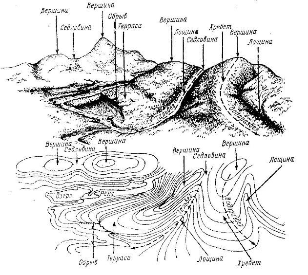
Of the variety of landforms, the most characteristic ones can be distinguished (Fig. 12).
Mountain(hill, height, hill) is a cone-shaped relief form towering above the surrounding area, the highest point of which is called the peak (3, 7, 12). The top in the form of a platform is called a plateau, the peak of a pointed shape is called a peak. The lateral surface of the mountain consists of slopes, the line of their confluence with the surrounding area is the sole, or base, of the mountain.
Rice. 12. Characteristic landforms:
1 - hollow; 2 - ridge; 3,7,12 - peaks; 4 - watershed; 5.9 - saddles; 6 - thalweg; 8 - river; 10 - break; eleven -
Basin or hollow,- This is a recess in the form of a bowl. The lowest point of the basin is the bottom. Its lateral surface consists of slopes, the line of their confluence with the surrounding area is called the edge.
Ridge 2 - this is a hill, gradually lowering in one direction and having two steep slopes, called slopes. The axis of the ridge between the two slopes is called the watershed line or watershed 4.
dell 1 - this is an elongated depression of the terrain, gradually lowering in one direction. The axis of the hollow between two slopes is called a weir line or thalweg 6. The varieties of the hollow are : valley- a wide hollow with gentle slopes, as well as ravine- a narrow hollow with almost steep slopes (cliffs 10) . The initial stage of a ravine is a ravine. A ravine overgrown with grass and shrubs is called beam. Sites sometimes located along the slopes of hollows, having the form of a ledge or steps with an almost horizontal surface, are called terraces 11.
Saddles 5, 9 are the low parts of the terrain between the two peaks. Roads often pass through saddles in the mountains; in this case the saddle is called pass.
The top of the mountain, the bottom of the basin and the lowest point of the saddle are characteristic points of the relief. The watershed and thalweg are characteristic lines of relief. The characteristic points and lines of the relief facilitate the recognition of its individual forms on the ground and their depiction on the map and plan.
The method of depicting the relief on maps and plans should make it possible to judge the direction and steepness of the slopes, as well as determine the marks of points in the terrain. However, it must be visible. There are various ways of depicting relief: perspective, shading with lines of different thicknesses, color wash(mountains are brown, hollows are green), horizontal. From an engineering point of view, the most advanced methods of depicting a relief are horizontals in combination with signatures of characteristic points marks (Fig. 13) and digital.
Horizontal A line on a map that connects points of equal elevation. If we imagine a section of the Earth's surface by a horizontal (level) surface R 0 , then the line of intersection of these surfaces, projected orthogonally onto a plane and reduced to a size on the scale of a map or plan, will be a horizontal line. If the surface R 0 located at a height H from the level surface, taken as the origin of the absolute heights, then any point on this horizontal line will have an absolute elevation equal to H. The image in the relief contours of the entire area of the terrain can be obtained as a result of the section of the surface of this area by a number of horizontal planes R 1 , R 2 , … R n , located at the same distance from each other. As a result, contour lines with marks are obtained on the map H + h, H + 2h etc.
Distance h between secant horizontal planes is called relief section height. Its value is indicated on a map or plan under a linear scale. Depending on the scale of the map and the nature of the depicted relief, the height of the section is different.
The distance between contour lines on a map or plan is called mortgage. The greater the laying, the less the steepness of the slope on the ground, and vice versa.

Rice. 13. Image of the terrain with contour lines
Contour property: contour lines never intersect, with the exception of an overhanging cliff, natural and artificial funnels, narrow ravines, steep cliffs, which are not displayed by contour lines, but are indicated by conventional signs; horizontal lines are continuous closed lines that can only end at the border of a plan or map; the thicker the horizontal, the steeper the terrain depicted, and vice versa.
The main relief forms are depicted by horizontal lines as follows (Fig. 14).
Images of the mountain and the basin (see Fig. 14, a, b), as well as a ridge and a hollow (see Fig. 14, c, g) are similar to each other. To distinguish them from each other, the direction of the slope is indicated at the horizontal. On some horizontal lines, marks of characteristic points are signed, and so that the top of the numbers is directed towards the rise of the slope.
Rice. 14. Image by contour lines of characteristic
landforms:
a - mountain; b - basin; c - ridge; G- hollow; d- saddle;
1 - top; 2 - bottom; 3 - watershed; 4 - thalweg
If, at a given height of the relief section, some of its characteristic features cannot be expressed, then additional semi- and a quarter of the horizontal are drawn, respectively, through half or a quarter of the accepted height of the relief section. Additional horizontals are shown with dotted lines.
To make it easier to read the contour lines on the map, some of them are thickened. With a section height of 1, 5, 10, and 20 m, every fifth horizontal line is thickened with marks that are multiples of 5, 10, 25, 50 m, respectively. With a section height of 2.5 m, every fourth horizontal line is thickened with marks that are multiples of 10 m.
The steepness of the slopes. The steepness of the slope can be judged by the magnitude of the deposits on the map. The smaller the laying (distance between horizontals), the steeper the slope. To characterize the steepness of the slope on the ground, the angle of inclination ν is used. Vertical angle called the angle enclosed between the line of the terrain and its horizontal laying. The angle ν can vary from 0º for horizontal lines to ± 90º for vertical lines. The greater the angle of inclination, the steeper the slope.
1.1 Types and landforms
In military affairs terrain understand the area of the earth's surface on which to conduct hostilities. The unevenness of the earth's surface is called terrain, and all objects located on it, created by nature or human labor (rivers, settlements, roads, etc.) - local items.
The relief and local objects are the main topographical elements of the terrain that affect the organization and conduct of combat, the use of military equipment in combat, the conditions for observation, firing, orientation, camouflage and maneuverability, i.e., determining its tactical properties.
A topographic map is an accurate display of all the most tactically important elements of the terrain, plotted in a mutually exact location relative to each other. It makes it possible to explore any territory in a relatively short time. Preliminary study of the terrain and decision-making for the performance of a particular combat mission by a subunit (unit, formation) is usually carried out on a map, and then refined on the ground.
The terrain, influencing combat operations, in one case can contribute to the success of the troops, and in the other have a negative effect. Combat practice convincingly shows that one and the same terrain can give more advantages to those who study it better and use it more skillfully.
According to the nature of the relief, the area is divided into flat, hilly and mountainous.
flat terrain characterized by small (up to 25 m) relative elevations and a relatively small (up to 2 °) steepness of slopes. Absolute heights are usually small (up to 300 m) (Fig. 1).
Rice. 1. Flat, open, slightly rugged terrain
The tactical properties of flat terrain depend mainly on the soil and vegetation cover and on the degree of ruggedness. Clayey, loamy, sandy loamy, peaty soils allow the unhindered movement of military equipment in dry weather and significantly impede movement during the rainy season, spring and autumn thaws. It can be indented by riverbeds, ravines and gullies, have many lakes and marshes, which significantly limit the ability to maneuver troops and reduce the rate of advance (Fig. 2).
Flat terrain is usually more favorable for the organization and conduct of an offensive and less favorable for defense.
 Rice. 2. Plain lake-forest closed rugged terrain
hilly area characterized by a wavy nature of the earth's surface, forming irregularities (hills) with absolute heights up to 500 m, relative elevations of 25 - 200 m and a prevailing steepness of 2-3 ° (Fig. 3, 4). The hills are usually composed of hard rocks, their tops and slopes are covered with a thick layer of loose rocks. The depressions between the hills are wide, flat or closed basins.
 Rice. 3. Hilly semi-closed rugged terrain
 Rice. 4. Hilly ravine-beam semi-closed rugged terrain
Hilly terrain provides for the movement and deployment of troops hidden from enemy ground observation, makes it easier to choose places for firing positions of missile troops and artillery, and provides good conditions for concentrating troops and military equipment. In general, it is favorable both for the offensive and for defense.
Mountain landscape represents areas of the earth's surface that are significantly elevated above the surrounding area (having absolute heights of 500 m or more) (Fig. 5). It is distinguished by a complex and varied relief, specific natural conditions. The main landforms are mountains and mountain ranges with steep slopes, often turning into rocks and rocky cliffs, as well as hollows and gorges located between mountain ranges. The mountainous area is characterized by a sharp rugged terrain, the presence of hard-to-reach areas, a sparse network of roads, a limited number of settlements, a rapid flow of rivers with sharp fluctuations in water levels, a variety of climatic conditions, and a predominance of rocky soils.
Combat operations in mountainous areas are considered as operations in special conditions. Troops often have to use mountain passes; observation and firing, orientation and target designation are difficult, at the same time it contributes to the secrecy of the location and movement of troops, facilitates the setting up of ambushes and engineering barriers, and the organization of camouflage.


Rice. 5. Mountainous rugged terrain
1.2 The essence of the image of the relief on maps by contour lines
The relief is the most important element of the terrain, which determines its tactical properties.
The image of the relief on topographic maps gives a complete and sufficiently detailed idea of the irregularities of the earth's surface, the shape and relative position, elevations and absolute heights of terrain points, the prevailing steepness and length of slopes.
 Rice. 6. The essence of the image of the relief by contour lines
The relief on topographic maps is depicted by horizontal lines in combination with conventional signs of cliffs, rocks, ravines, gullies, stone rivers, etc. The image of the relief is supplemented by elevation marks of characteristic points of the area, contour lines, relative heights (depths) and slope direction indicators (bergstrokes) . On all topographic maps, the relief is depicted in the Baltic system of heights, that is, in the system of calculating absolute heights from the average level of the Baltic Sea.
1.3 Types of contour lines
Horizontal- a closed curved line on the map, which corresponds to a contour on the ground, all points of which are located at the same height above sea level.
There are the following horizontal lines:
- main(solid) - relief section corresponding to the height;
- thickened - every fifth main horizontal; stands out for ease of reading the relief;
- d additional horizontals(semi-horizontals) - are drawn by a broken line at the height of the relief section equal to half of the main one;
- auxiliary - are depicted as short dashed thin lines, at an arbitrary height.
Distance between two adjacent main contour lines in height are called the height of the relief section. The height of the relief section is signed on each sheet of the map under its scale. For example: "Solid contours are drawn through 10 meters."
To facilitate the calculation of contour lines when determining the heights of points on the map, all solid contour lines corresponding to the fifth multiple of the height of the section are drawn thickened and a number indicating the height above sea level is put on it.
In order to quickly determine the nature of surface irregularities on maps when reading a map, special slope direction indicators are used - berghashes- in the form of short dashes placed on the horizontals (perpendicular to them) in the direction of the slopes. They are placed on the bends of contour lines in the most characteristic places, mainly at the tops of saddles or at the bottom of basins.
Additional contours(semi-horizontals) are used to display the characteristic forms and details of the relief (bends of slopes, peaks, saddles, etc.), if they are not expressed by the main horizontals. In addition, they are used to depict flat areas, when the laying between the main contours is very large (more than 3 - 4 cm on the map).
Auxiliary horizontals used to depict individual details of the relief (saucers in the steppe regions, depressions, individual hillocks on flat terrain), which are not transmitted by the main or additional horizontals.
1.4 Depiction by contour lines of typical landforms
The relief on topographic maps is depicted by curved closed lines connecting points of the terrain that have the same height above the level surface, taken as the origin of the heights. Such lines are called horizontal lines. The image of the relief with contour lines is supplemented by labels of absolute heights, characteristic points of the terrain, some contour lines, as well as numerical characteristics of relief details - height, depth or width (Fig. 7).
 Rice. 7. Representation of the relief by conventional signs
Some typical forms of terrain on the maps are displayed not only by the main, but also by additional and auxiliary contour lines (Fig. 8).
 Rice. 8. Image of typical landforms
2. Determination on the map of absolute heights and relative elevations of terrain points, ascents and descents, steepness of slopes
2.1. Determination on the map of absolute heights and relative elevations of terrain points
 Rice. 9. Determination on the map of absolute heights of relative elevations of terrain points
Altitude- height of a point on the earth's surface above sea level; is determined by the heights and contour lines (in Fig. 9, these are the heights with marks 33.1 and 49.8).
Relief section height- the distance in height between two adjacent cutting planes.
Relative height(mutual excess of points)- the height of a terrain point above another, it is defined as the difference in the absolute heights of these points (in Fig. 9, the relative height is 16.7 (49.8-33.1)).
 Rice. 10. Definition on the map of ascents and descents on the route of movement (route profile).
 Rice. 11. Determination on the map of the steepness of the slopes
Profile- a drawing depicting a section of the terrain with a vertical plane.
For greater expressiveness of the terrain, the vertical scale of the profile is taken 10 or more times larger than the horizontal one.
In this regard, the profile, transmitting the mutual excess of points, distorts (increases) the steepness of the slopes.
To build a profile, you need(Fig. 10) :
- draw a profile line (travel route) on the map, attach a sheet of graphed (millimetric) paper to it, transfer to its edge with short lines the places of contour lines, the inflection points of the slopes and local objects that the profile line cuts, and sign their heights;
- sign on a sheet of graphed paper at the horizontal lines the heights corresponding to the heights of the contour lines on the map, conventionally taking the gaps between these lines as the height of the section (set the vertical scale);
- from all dashes indicating the intersections of the profile line with elevation marks of contour lines, inflection points of slopes and local objects, lower the perpendiculars until they intersect with parallel lines corresponding to the marks and mark the resulting intersection points;
- connect the intersection points of a smooth curve, which will depict the terrain profile (ascents and descents on the route of movement).
The steepness of the slope on the map is determined by the location - the distance between two adjacent main or thickened horizontals; the smaller the laying, the steeper the slope.
To determine the steepness of the slope, it is necessary to measure the distance between the horizontals with a compass, find the corresponding segment on the laying chart and read the number of degrees (Fig. 11).
 Under relief the earth's surface is understood as the totality of all its forms. To depict the relief on a topographic map, horizontal lines, elevation marks and conventional signs are used. The image of the relief by contour lines makes it possible to recognize the forms and elements of the relief from the map, to identify their interrelations and to obtain its characteristics. The contour lines and their relative position are transmitted (Fig. 1).
 picture 1
 The terrain is very varied. Most main:
Mountain - a hill on the earth's surface in the form of a dome or cone; depicted as closed contour lines encircling one another (see Fig. 2. a). The slope direction indicators are located on the outside, and they distinguish the top at point C, the soles of the mountain at points A and B, a gentle slope along the AC line, and a steep slope along the BC line. If the slope turns from gentle to steep, then it is called a cliff.
 figure 2
 A cliff is a very steep cliff.
Hollow - a recess, closed on all sides; is depicted by the same closed contour lines as the mountain, but the slope direction indicators are turned inward, towards the bottom of the basin. It distinguishes along the lines KL and MN - slopes or sides and LM - the bottom of the basin (Fig. 2, b).
A hill, depression or basin can be identified by the slope indicators - berghstrich (Fig. 2). So, if the berghstrich (short dash) is directed to the outside, then this is a hill, if to the inside - a hollow.
A hollow (Fig. 2, c) is a hollow of a gutter-like shape. It distinguishes slopes along the lines ab and cd and the bottom of the hollow, along which the thalweg line AB runs. The thalweg is usually the bed of the drain. A hollow with wide and gentle slopes is called a valley, and a narrow and deep valley in mountainous areas is called a gorge. Sites located along the slopes of hollows, having the form of a ledge or steps with a horizontal surface, are called terraces.
The contours that reveal the hollow are convexly turned towards the more elevated part of the terrain. A narrow hollow with branches is called a ravine.
The ridge - (spur, ridge) is depicted by a system of elongated U - shaped horizontals (Fig. 1). This is a landform opposite to a hollow.
If a line is drawn through the points where the horizontals have the greatest steepness, then it will separate the slopes (slopes) of opposite directions. This will be the watershed.
A saddle is an area in which two opposite sides rise and two other opposite sides decrease (Fig. 2, d). Point C is the saddle point.
 Two heads and six legs; four walk, and two lie still
 Self-esteem - what is it: concept, structure, types and levels
 Cassandra's Path, or Pasta Adventures War on Earth and Underground