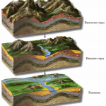
View of the landform in absolute height. "Relief and landforms
 Under relief the earth's surface is understood as the totality of all its forms. To depict the relief on a topographic map, horizontal lines, elevation marks and conventional signs are used. The image of the relief by contour lines makes it possible to recognize the forms and elements of the relief from the map, to identify their interrelations and to obtain its characteristics. The contour lines and their relative position are transmitted (Fig. 1).
 picture 1
 The terrain is very varied. Most main:
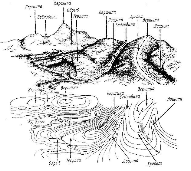
Mountain - a hill on the earth's surface in the form of a dome or cone; depicted as closed contour lines encircling one another (see Fig. 2. a). The slope direction indicators are located on the outside, and they distinguish the top at point C, the soles of the mountain at points A and B, a gentle slope along the AC line, and a steep slope along the BC line. If the slope turns from gentle to steep, then it is called a cliff.
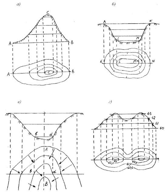 figure 2
 A cliff is a very steep cliff.
Hollow - a recess, closed on all sides; is depicted by the same closed contour lines as the mountain, but the slope direction indicators are turned inward, towards the bottom of the basin. It distinguishes along the lines KL and MN - slopes or sides and LM - the bottom of the basin (Fig. 2, b).
A hill, depression or basin can be identified by the slope indicators - berghstrich (Fig. 2). So, if the berghstrich (short dash) is directed to the outside, then this is a hill, if to the inside - a hollow.
A hollow (Fig. 2, c) is a hollow of a gutter-like shape. It distinguishes slopes along the lines ab and cd and the bottom of the hollow, along which the thalweg line AB runs. The thalweg is usually the bed of the drain. A hollow with wide and gentle slopes is called a valley, and a narrow and deep valley in mountainous areas is called a gorge. Sites located along the slopes of hollows, having the form of a ledge or steps with a horizontal surface, are called terraces.
The contours that reveal the hollow are convexly turned towards the more elevated part of the terrain. A narrow hollow with branches is called a ravine.
The ridge - (spur, ridge) is depicted by a system of elongated U - shaped horizontals (Fig. 1). This is a landform opposite to a hollow.
If a line is drawn through the points where the horizontals have the greatest steepness, then it will separate the slopes (slopes) of opposite directions. This will be the watershed.
A saddle is an area in which two opposite sides rise and two other opposite sides decrease (Fig. 2, d). Point C is the saddle point.
800+ abstracts
for only 300 rubles!
* Old price - 500 rubles.
The promotion is valid until 31.08.2018
Lesson questions:
1. Types and forms of terrain. The essence of the image of the relief on the maps by contour lines. Types of horizontals. Image by contour lines of typical landforms.
1.1 Types and forms of terrain.
In military affairs terrain understand the area of the earth's surface on which to conduct hostilities. The unevenness of the earth's surface is called terrain, and all objects located on it, created by nature or human labor (rivers, settlements, roads, etc.) - local items.
The relief and local objects are the main topographical elements of the terrain that affect the organization and conduct of combat, the use of military equipment in combat, the conditions for observation, firing, orientation, camouflage and maneuverability, i.e., determining its tactical properties.
A topographic map is an accurate representation of all the most tactically important elements of the terrain, plotted in a mutually exact arrangement relative to each other. It makes it possible to explore any territory in a relatively short time. Preliminary study of the terrain and decision-making for the performance of a particular combat mission by a subunit (unit, formation) is usually carried out on a map, and then refined on the ground.
The terrain, influencing combat operations, in one case can contribute to the success of the troops, and in the other have a negative effect. Combat practice convincingly shows that one and the same terrain can give more advantages to those who study it better and use it more skillfully.
According to the nature of the relief, the area is divided into flat, hilly and mountainous.
flat terrain characterized by small (up to 25 m) relative elevations and a relatively small (up to 2 °) steepness of slopes. Absolute heights are usually small (up to 300 m) (Fig. 1).
The tactical properties of flat terrain depend mainly on the soil and vegetation cover and on the degree of ruggedness. Its clayey, loamy, sandy loamy, peaty soils allow the unimpeded movement of military equipment in dry weather and significantly impede movement during the rainy season, spring and autumn thaws. It can be indented by riverbeds, ravines and gullies, have many lakes and swamps, which significantly limit the ability to maneuver troops and reduce the rate of advance (Fig. 2).
Flat terrain is usually more favorable for the organization and conduct of an offensive and less favorable for defense.
hilly area characterized by a wavy nature of the earth's surface, forming irregularities (hills) with absolute heights up to 500 m, relative elevations of 25 - 200 m and a prevailing steepness of 2-3 ° (Fig. 3, 4). The hills are usually composed of hard rocks, their tops and slopes are covered with a thick layer of loose rocks. The depressions between the hills are wide, flat or closed basins.
Hilly terrain provides for the movement and deployment of troops hidden from enemy ground observation, makes it easier to choose places for firing positions of missile troops and artillery, and provides good conditions for concentrating troops and military equipment. In general, it is favorable both for the offensive and for defense.
Mountain landscape represents areas of the earth's surface that are significantly elevated above the surrounding area (having absolute heights of 500 m or more) (Fig. 5). It is distinguished by a complex and varied relief, specific natural conditions. The main landforms are mountains and mountain ranges with steep slopes, often turning into rocks and rocky cliffs, as well as hollows and gorges located between mountain ranges. The mountainous area is characterized by a sharp rugged terrain, the presence of hard-to-reach areas, a sparse network of roads, a limited number of settlements, a rapid flow of rivers with sharp fluctuations in water levels, a variety of climatic conditions, and a predominance of rocky soils.
Combat operations in mountainous areas are considered as operations in special conditions. Troops often have to use mountain passes; observation and firing, orientation and target designation are difficult, at the same time it contributes to the secrecy of the location and movement of troops, facilitates the setting up of ambushes and engineering barriers, and the organization of camouflage.
1.2 The essence of the image of the relief on maps by contour lines.
The relief is the most important element of the terrain, which determines its tactical properties.
The image of the relief on topographic maps gives a complete and sufficiently detailed idea of the irregularities of the earth's surface, the shape and relative position, elevations and absolute heights of terrain points, the prevailing steepness and length of slopes.
1.3 Types of contour lines.
Horizontal- a closed curved line on the map, which corresponds to a contour on the ground, all points of which are located at the same height above sea level.
There are the following horizontal lines:
- main(solid) - relief section corresponding to the height;
- thickened - every fifth main horizontal; stands out for ease of reading the relief;
- additional horizontals(semi-horizontals) - are drawn by a broken line at the height of the relief section equal to half of the main one;
- auxiliary - are depicted as short dashed thin lines, at an arbitrary height.
Distance between two adjacent main contour lines in height are called the height of the relief section. The height of the relief section is signed on each sheet of the map under its scale. For example: "Solid contours are drawn through 10 meters."
To facilitate the calculation of contour lines when determining the heights of points on the map, all solid contour lines corresponding to the fifth multiple of the height of the section are drawn thickened and a number indicating the height above sea level is put on it.
In order to quickly determine the nature of surface irregularities on maps when reading a map, special slope direction indicators are used - berghashes- in the form of short dashes placed on the horizontals (perpendicular to them) in the direction of the slopes. They are placed on the bends of contour lines in the most characteristic places, mainly at the tops of saddles or at the bottom of basins.
Additional contours(semi-horizontals) are used to display the characteristic forms and details of the relief (bends of slopes, peaks, saddles, etc.), if they are not expressed by the main horizontals. In addition, they are used to depict flat areas, when the laying between the main contours is very large (more than 3 - 4 cm on the map).
Auxiliary horizontals used to depict individual details of the relief (saucers in the steppe regions, depressions, individual hillocks on flat terrain), which are not transmitted by the main or additional contour lines.
1.4 Depiction by contour lines of typical landforms.
The relief on topographic maps is depicted by curved closed lines connecting points of the terrain that have the same height above the level surface, taken as the origin of the heights. Such lines are called horizontal lines. The image of the relief with contour lines is supplemented by labels of absolute heights, characteristic points of the terrain, some contour lines, as well as numerical characteristics of relief details - height, depth or width (Fig. 7).
Some typical forms of terrain on the maps are displayed not only by the main, but also by additional and auxiliary contour lines (Fig. 8).
 |
|
|
|
Rice. 8. Image of typical landforms |
|||


2. Determination on the map of absolute heights and relative elevations of terrain points, ascents and descents, steepness of slopes.
2.1. Determination on the map of absolute heights and relative elevations of terrain points
2.2. Definition on the map of ascents and descents on the route.
Rice. ten. Definition on the map of ascents and descents on the route of movement (route profile).
Rice. eleven. Determination on the map of the steepness of the slopes |
Profile- a drawing depicting a section of the terrain with a vertical plane.
|


2.3. Determination on the map of the steepness of the slopes.
The steepness of the slope on the map is determined by the location - the distance between two adjacent main or thickened horizontals; the smaller the laying, the steeper the slope \.
To determine the steepness of the slope, it is necessary to measure the distance between the horizontals with a compass, find the corresponding segment on the laying chart and read the number of degrees (Fig. 11).
On steep slopes, this distance is measured between thickened contours and the steepness of the slope is determined from the graph on the right.
3. Conventional signs of relief elements that are not expressed by contour lines.
|
Ice cliffs (barriers) and outcrops of fossil ice (8 - height of the cliff in meters) |
|
|
|
Sod ledges (edges) that are not expressed by horizontal lines |
|
Shafts coastal, historical, etc., not expressed by contour lines (3 - height in meters) |
|
1) Dry channels in one line (less than 5 m wide); |
Height marks |
|
Command Height Marks |
|
|
Landmark elevations |
|
Main passes, marks of their heights and duration |
|
Passes, marks of their heights and duration |
|
Karst and thermokarst sinkholes not expressed on the map scale |
Pits that are not expressed on the scale of the map |
|
Pits expressed in map scale |
|
Rocks-outliers that have a landmark value (10-height in meters) |
|
Rocks-outliers that do not have a landmark value |
|
|
Dikes and other narrow, steeply walled hard rock ridges (5 is the height of the ridge in meters) |
Mud volcano craters |
|
Volcanic craters not expressed on the map scale |
|
Mounds and mounds that are not expressed on the scale of the map |
|
Mounds and mounds, expressed on the scale of the map (5 - height in meters) |
|
Clusters of stones |
|
Separately lying stones (3 - height in meters) |
|
Entrances to caves and grottoes |


Abstracts
Military topography
military ecology
Military Medical Training
Engineering training
fire training
Fundamentals of external and internal ballistics. Hand grenades. Grenade launchers and rocket-propelled grenades.
9.1. TYPES AND ELEMENTARY FORMS OF RELIEF
Relief -
a set of uneven land, the bottom of the oceans and seas, diverse in shape, size, origin, age and history of development. It is composed of positive (convex) and negative (concave) forms. Main forms
relief are: mountain, hollow, ridge, hollow and saddle.
In addition to the above forms, the relief has details
. Relief details include: ravines, gullies, mounds, embankments, cuts, ledges, quarries, etc.
All varieties of forms and relief details consist of elements. Main relief elements
are: base (bottom), slope (slope), top (bottom), height (depth), steepness and direction of the slope, watershed and catchment lines (thalweg). The main forms, details and relief elements are shown in fig. 9.1.
Rice. 9.1. Basic forms, details and relief elements
mountain
called a domed or cone-shaped elevation of the earth's surface. The highest point of the mountain is called summit, from which the terrain drops in all directions. The pointed top of the mountain is called peak, and flat plateau. The side of a mountain is called slope or slope. The base of the mountain, which is the line of transition of the slopes into the surrounding flat surface, is called sole the mountains. A small mountain, up to 200 m high, is called hill. The mound is called barrow.
Basin
is a closed cone-shaped recess of the earth's surface. The lower part of the basin is called the bottom, the side surface is called the slope, the line of transition of the side surface to the surrounding area is eyebrow. The small basin is called pit, funnel or depression.
Ridge -
it is a hill elongated in one direction with two opposite slopes. The line of intersection of its slopes, passing along the highest points of the ridge, is called watershed, from which water and precipitation slide down two slopes.
dell
- an elongated recess. The line along the hollow, passing through the lowest points, is called watercourse or thalweg, and the sides stingrays, which end eyebrows. If you look down the watercourse, then the excesses in this direction will be negative, and to the right, left and back - positive. Wide hollows with gentle slopes are called valleys, and with steep and stony - gorges. Hollows in the form of deep gullies in valleys, formed under the action of flowing waters, are called ravines. Over time, the cliffs of the ravine crumble, overgrow with grass, woody vegetation and form beams.
saddle -
this is a lower section of the watershed between two hills and two hollows, diverging from the saddle in opposite directions. In mountainous areas, a saddle is called a pass.
To depict the terrain at characteristic points of saddles, on the tops of mountains, at the bottom of basins, on the watersheds of ridges, watercourses of hollows, on the edges of hollows and hollows, on the soles of mountains and at the points of inflections of slopes during topographic survey, their heights are determined, which are then signed on the map around these points.
9.2. ESSENCE OF RELIEF IMAGES BY HORIZONTALS
On topographic maps, the relief is depicted by contour lines, i.e., curved closed lines, each of which is an image on the map of a horizontal contour of unevenness, all points of which on the ground are located at the same height above sea level.
In order to better understand the essence of the depiction of the relief by contour lines, let us imagine an island in the form of a mountain gradually flooded with water. Let us assume that the water level successively stops at equal intervals in height, equal to h meters (Fig. 9.2).

Rice. 9.2. The essence of the image of the relief by contour lines
For each water level, starting from the initial ( AB) will obviously match its coastline ( CD, KL, MN, RS) in the form of a closed curve, all points of which have the same height.
These lines can also be considered as traces of the section of uneven terrain by level surfaces parallel to the level surface of the sea, from which the heights are calculated. Based on this, the distance h in height between adjacent secant surfaces is called section height.
If all these lines of equal heights are projected onto the surface of the earth's ellipsoid and depicted on a map on a given scale, then we will get an image of a mountain on it in plan in the form of a system of closed curved lines ab, cd, kl, tp and rs. These will be horizontal.
Considering the essence of horizontals, we can draw the following conclusion:
a) each contour on the map is a horizontal projection of a line of equal heights on the ground, depicting the planned outline of the unevenness of the earth's surface. Thus, according to the pattern and the mutual position of the horizontals, one can perceive the forms, the mutual position and the relationship of irregularities;
b) since the contour lines on the map are drawn at regular intervals in height, then by the number of contour lines on the slopes it is possible to determine the height of the slopes and the mutual excess of points on the earth's surface: the more contour lines on the slope, the higher it is;
in) laying
horizontal lines
, i.e. distances in plan between adjacent horizontals, depend on the steepness of the slope: the steeper the slope, the less the laying. Therefore, by the magnitude of the foundation, one can judge the steepness of the slope.
9.3. TYPES OF HORIZONTALS
Section height
relief on the map depends on scale cards and character relief. For flat and hilly terrain, its value is equal to 0.02 of the map scale value (for example, on maps of scales 1:50,000 and 1:100,000, the normal section height is 10 and 20 m, respectively). On maps of high-mountainous regions, so that the image of the relief is not obscured due to excessive density of contour lines and is better readable, the height of the section is taken twice as normal (on a map of a scale of 1:25,000 - 10 m, 1:50,000 - 20 m, 1:100,000 - 40 m, 1:200,000 - 80 m). On maps of flat-plain regions at scales of 1:25,000 and 1:200,000, the height of the section is taken to be half the normal height, i.e., 2.5 and 20 m, respectively.
Contours on the map corresponding to the height of the section set for it are drawn solid lines and are called main
, or solid
, contour lines (Fig. 9.3).
It often happens that important details of the relief are not expressed on the map by the main horizontal lines. In these cases, in addition to the main horizontals, half
(semi-horizontals
), which are drawn on the map through half the main height of the section. Unlike the main ones, half horizontals are drawn with broken lines.
In some places, where the necessary details of the relief are not expressed by the main and half contour lines, more lines are drawn between them. auxiliary
horizontal - about quarter heights sections. They are also drawn with broken lines, but with shorter links.

Rice. 9.3. Main, half and auxiliary horizontals
To facilitate the calculation of contour lines when determining the heights of points on the map all solid contour lines corresponding to fivefold section height, draw a thickened line ( thickened horizontal).
The main height of the section is indicated on each sheet of the map - under the southern side of its frame. For example, the inscription "Solid contour lines are drawn through 10 m" means that on this sheet all the horizontal lines shown by solid lines are a multiple of 10 m, and thickened ones are a multiple of 50 m.
9.4. IMAGE OF HORIZONTALS OF ELEMENTARY FORMS OF RELIEF
On fig. 9.4. elementary relief forms are shown separately by horizontal lines. The figure shows that a small mountain (hill) and a hollow look, in general, the same - in the form of a system of closed contour lines encircling each other. The images of the ridge and the hollow are similar to each other. They can only be distinguished by the direction of the slopes.

Rice. 9.4. Image by contour lines
elementary landforms
Slope direction indicators, or berghashes
, serve as short dashes, arranged horizontally (perpendicular to them) in the direction of slopes. They are placed on the curves of contours in the most characteristic places, mainly at the peaks, saddles or at the bottom of the basins, as well as on gentle slopes - in places that are difficult to read.
They also help determine the direction of the slopes. elevations on maps:
- contour lines , i.e., digital signatures on some horizontal lines, indicating in meters their height above sea level. The top of these numbers is always facing upward slope;
- elevation marks individual, most characteristic points of the terrain - the tops of mountains and hills, the highest points of watersheds, the lowest points of valleys and ravines, water levels (cuts) in rivers and other reservoirs, etc.
On maps of a scale of 1:100,000 and larger, the elevations of points above sea level are signed with an accuracy of 0.1 m, and on maps of 1:200,000 and smaller - to whole meters. This must be kept in mind in order not to confuse points when indicating and identifying their marks on maps of different scales.
9.5. FEATURES OF IMAGES OF PLAIN AND MOUNTAIN RELIEF BY HORIZONTALS
Irregularities with large, clearly defined and smooth forms are most clearly represented by horizontal lines. The image of a flat relief is less expressive, since the horizontals here pass at a considerable distance from one another and do not express many details that lie between the horizontals of the main section. Therefore, along with the main (solid) contour lines, semi-horizontal lines are widely used on maps of flat regions. This improves the readability and detail of flat relief images. When studying such a relief and determining its numerical characteristics from the map, one must be especially careful not to confuse the half and auxiliary horizontals with the main ones.
When studying a mountainous and strongly rugged relief on a map, on the contrary, one has to deal with a very dense arrangement of contour lines. With a large steepness of the slopes, the laying in some places is so small that it is not possible to draw all the horizontals here separately.
Therefore, when depicting slopes on maps, the steepness of which is greater than the limiting one, the horizontals are drawn together one with the other or with a dotted line, leaving only two or three intermediate horizontals between the thickened horizontals instead of four. In such places, when determining the heights of points or the steepness of slopes on a map, thickened contour lines should be used.
9.6. CONVENTIONAL SIGNS OF RELIEF ELEMENTS NOT EXPRESSED IN HORIZONTALS
Objects and relief details that cannot be depicted by contour lines (more than 45º) are shown on maps with special conventional symbols (Fig. 9.5).

Rice. 9.5. Relief symbols
Such objects include cliffs, rocks, scree, ravines, gullies, ramparts, road embankments and cuts, mounds, pits, sinkholes. The numbers accompanying the symbols of these objects indicate their relative heights (depths) in meters.
Conventional signs of natural relief formations and the signatures of characteristics related to them, as well as horizontal lines, are printed in brown ink, and artificial ones (embankments, excavations, barrows, etc.) are printed in black.

Rice. 9.6. Fortified field terraces (figures - heights in meters)

Rice. 9.7. Mounds (numbers - heights in meters):
a) - on the cards; b - on the plans
The following are depicted by special conventional black symbols: remnant rocks - large separately lying stones and clusters of stones, which are landmarks, indicating their relative heights; caves, grottoes and underground workings with their numerical characteristics (in the numerator - the average diameter of the entrance, in the denominator - the length or depth in meters); tunnels indicating their height and width in the numerator, and their length in the denominator. On roads and trails crossing mountain ranges, passes are marked with an indication of their height above sea level and the time of action.
The relief of eternal snows (firn fields) and glaciers is also depicted by horizontal lines, but in blue. The same color shows all the symbols related to it (ice cliffs, ice cracks, icing) and numerical marks of heights and contours.

Rice. 9.8. The relief of eternal snows and glaciers
a) firn fields (eternal snows), b) glaciers, c) glacial cracks, d) moraines, e) stone rivers. e) stony placers. g) rocks and rocky cliffs, h) steep slopes less than 1 cm long on the map. i) steep slopes more than 1 cm long on the map. j) borders of firn fields
9.7. PECULIARITIES OF RELIEF DISPLAY ON MAP SCALE 1:500,000 AND 1:1,000,000
The relief on small-scale topographic maps, as well as on maps of larger scales, is depicted by contour lines and conventional signs, but more generally. They display only the general nature of the relief - its structure, main forms, the degree of its vertical and horizontal dissection.
The height of the main section when depicting flat areas on both maps is set to 50 m, and mountainous - 100 m. On a map of a scale of 1: 1,000,000, in addition, a section height of 200 m is used to depict areas located above 1,000 m above sea level .
Relief objects that are not expressed as contour lines are shown only those that are necessary to characterize the terrain or are important landmarks. They are marked with the same symbols as on other maps, but smaller.
The main feature is the depiction of mountainous terrain. For greater clarity, its image is supplemented by horizontal lines with the so-called laundering and layered coloring book by the heights.

Rice. 9.9. Map without hillshade (top) and with hillshade (bottom)
laundering
, i.e. shading of the slopes of the most important forms of mountainous relief, makes the image more expressive and plastic, allowing you to visually feel its three-dimensional forms. Shading is done with gray-brown paint according to the principle - the more significant, higher and steeper the slope, the stronger the tone of the hillshade.
Thanks to hillshading, the main mountain ranges and massifs, their most important spurs and peaks, passes, ledges of highlands, deep valleys and canyons are well distinguished. The direction and comparative steepness of the slopes, the shape of the ridges (sharp, rounded, etc.) and the difference in height of the main mountain ranges are clearly perceived.
Layered coloring by height steps
visually displays the high-altitude characteristics of the mountainous relief and enhances the plastic effect of its image. It is performed with orange paint of various tones according to the principle - the higher, the darker. In this case, the image of the relief is, as it were, divided into separate high-altitude layers (steps), according to the color tone of which their absolute heights and mutual excesses are easily distinguished. The color tone of the layers intensifies after 400, 600 or 1000 m, depending on their absolute heights. The scale of elevation steps adopted on the map is indicated on each sheet under the southern side of its frame.
Questions and tasks for self-control
- Give the definition of "relief", "horizontal", "sectional height", "laying", "laying a slope"
- Name the main forms of the part and relief elements, give them a brief description.
- What are the main horizontal lines?
- For what purposes are half and auxiliary horizontals used and at what vertical distance are they drawn on the map?
- What is the purpose of the berghstres on the map?
- What colors are used to depict relief on maps?
- What is the essence of the hillshade method for depicting relief on maps?
- What is the essence of the hypsometric method for depicting relief on maps?
- How are the digital designations located at the signatures of the contour lines?
- What relief features are marked on the maps with special symbols?
- With the help of contour lines, show in the drawing a mountain, a ridge, a saddle, a basin, a hollow.
- What are the features of the relief image by contour lines on flat and mountainous terrain?
- Name the types of slopes. How are they shown on the maps?
- What are the features of the relief image on maps of scales 1:1,000,000 and 1:500,000?
Types and forms of terrain. The essence of the image of the relief on the maps by contour lines. Types of horizontals. Image by contour lines of typical landforms
Types and forms of terrain.
In military affairs terrain understand the area of the earth's surface on which to conduct hostilities. The unevenness of the earth's surface is called terrain, and all objects located on it, created by nature or human labor (rivers, settlements, roads, etc.) - local items.
The relief and local objects are the main topographical elements of the terrain that affect the organization and conduct of combat, the use of military equipment in combat, the conditions for observation, firing, orientation, camouflage and maneuverability, i.e., determining its tactical properties.
A topographic map is an accurate representation of all the most tactically important elements of the terrain, plotted in a mutually exact arrangement relative to each other. It makes it possible to explore any territory in a relatively short time. Preliminary study of the terrain and decision-making for the performance of a particular combat mission by a subunit (unit, formation) is usually carried out on a map, and then refined on the ground.
The terrain, influencing combat operations, in one case can contribute to the success of the troops, and in the other have a negative effect. Combat practice convincingly shows that one and the same terrain can give more advantages to those who study it better and use it more skillfully.
According to the nature of the relief, the area is divided into flat, hilly and mountainous.
flat terrain characterized by small (up to 25 m) relative elevations and a relatively small (up to 2 °) steepness of slopes. Absolute heights are usually small (up to 300 m) (Fig. 1).
Rice. 1. Flat, open, slightly rugged terrain
The tactical properties of flat terrain depend mainly on the soil and vegetation cover and on the degree of ruggedness. Its clayey, loamy, sandy loamy, peaty soils allow the unimpeded movement of military equipment in dry weather and significantly impede movement during the rainy season, spring and autumn thaws. It can be indented by riverbeds, ravines and gullies, have many lakes and swamps, which significantly limit the ability to maneuver troops and reduce the rate of advance (Fig. 2).
Flat terrain is usually more favorable for the organization and conduct of an offensive and less favorable for defense.
Rice. 2. Plain lake-forest closed rugged terrain
The hilly terrain is characterized by the undulating nature of the earth's surface, which forms irregularities (hills) with absolute heights of up to 500 m, relative elevations of 25–200 m, and a prevailing steepness of 2–3° (Fig. 3, 4). The hills are usually composed of hard rocks, their tops and slopes are covered with a thick layer of loose rocks. The depressions between the hills are wide, flat or closed basins.
Rice. 3. Hilly semi-closed rugged terrain
Rice. 4. Hilly ravine-beam semi-closed rugged terrain
Hilly terrain provides movement hidden from enemy ground observation
and deployment of troops, facilitates the choice of places for firing positions of missile troops and artillery, and provides good conditions for the concentration of troops and military equipment. In general, it is favorable both for the offensive and for defense.
Mountain landscape represents areas of the earth's surface that are significantly elevated above the surrounding area (having absolute heights of 500 m or more) (Fig. 5). It is distinguished by a complex and varied relief, specific natural conditions. The main landforms are mountains and mountain ranges with steep slopes, often turning into rocks and rocky cliffs, as well as hollows and gorges located between mountain ranges. The mountainous area is characterized by a sharp rugged terrain, the presence of hard-to-reach areas, a sparse network of roads, a limited number of settlements, a rapid flow of rivers with sharp fluctuations in water levels, a variety of climatic conditions, and a predominance of rocky soils.
Combat operations in mountainous areas are considered as operations in special conditions. Troops often have to use mountain passes; observation and firing, orientation and target designation are difficult, at the same time it contributes to the secrecy of the location and movement of troops, facilitates the setting up of ambushes and engineering barriers, and the organization of camouflage.
Rice. 5. Mountainous rugged terrain
The essence of the image of the relief on the maps by contour lines.
The relief is the most important element of the terrain, which determines its tactical properties.
The image of the relief on topographic maps gives a complete and sufficiently detailed idea of the irregularities of the earth's surface, the shape and relative position, elevations and absolute heights of terrain points, the prevailing steepness and length of slopes.
Rice. 6. The Essence of Relief Representation by Contours Relief on topographic maps is depicted by contour lines in combination with conventional signs of cliffs, rocks, ravines, gullies, stone rivers, etc.
The image of the relief is supplemented with elevation marks of characteristic points of the area, signatures of contour lines, relative heights (depths) and indicators of the direction of slopes (berg-strokes). For everyone
On topographic maps, the relief is depicted in the Baltic system of heights, that is, in the system of calculating absolute heights from the average level of the Baltic Sea.
Types of contour lines.
Horizontal- a closed curved line on the map, which corresponds to a contour on the ground, all points of which are located at the same height above sea level.
There are the following horizontal lines:
- basic (solid) - corresponding to the height of the relief section;
- thickened- every fifth main horizontal; stands out for ease of reading the relief;
- additional horizontals (semi-horizontals)- are drawn by a broken line at the height of the relief section equal to half of the main one;
- auxiliary- are depicted by short dashed thin lines, at an arbitrary height.
The distance between two adjacent main horizontals in height is called the height of the relief section. The height of the relief section is signed on each sheet of the map under its scale. For example: "Solid contours are drawn through 10 meters."
To facilitate the calculation of contour lines when determining the heights of points on the map, all solid contour lines corresponding to the fifth multiple of the height of the section are drawn thickened and a number indicating the height above sea level is put on it.
In order to quickly determine the nature of the surface irregularities on the maps when reading the map, special indicators of the direction of the slopes - berghstriches - are used in the form of short dashes placed on horizontal lines (perpendicular to them) in the direction of slopes. They are placed on the bends of contour lines in the most characteristic places, mainly at the tops of saddles or at the bottom of basins.
Additional contours(semi-horizontals) are used to display the characteristic forms and details of the relief (bends of slopes, peaks, saddles, etc.), if they are not expressed by the main horizontals. In addition, they are used to depict flat areas, when the laying between the main contours is very large (more than 3 - 4 cm on the map).
Auxiliary horizontals used to depict individual details of the relief (saucers in the steppe regions, depressions, individual hillocks on flat terrain), which are not transmitted by the main or additional horizontals.
Image by contour lines of typical landforms.
The relief on topographic maps is depicted by curved closed lines connecting points of the terrain that have the same height above the level surface, taken as the origin of the heights. Such lines are called horizontal lines. The image of the relief with contour lines is supplemented by labels of absolute heights, characteristic points of the terrain, some contour lines, as well as numerical characteristics of relief details - height, depth or width (Fig. 7).
Rice. 7. Representation of the relief by conventional signs
Some typical forms of terrain on the maps are displayed not only by the main, but also by additional and auxiliary contour lines (Fig. 8).
Rice. 8. Image of typical landforms
Landform types and their origin
Depending on the length (size) and the predominance of certain forms of relief, types of relief are distinguished : flat, hilly and mountainous terrains.
Forms and types of relief are, as mentioned above, the result of geological processes, they are composed of certain rocks and are subdivided according to their origin depending on the predominant factor - the force that caused their formation.
The forms and types of relief caused by the activity of endogenous forces, i.e., formed due to the movements of the earth's crust and lithosphere (vertical or oscillatory, horizontal or mountain-forming) and the accompanying magmatism and metamorphism, are called tectonic forms . These forms and types include the largest landforms: macro -, megareliefplanetaryrelief , arising and lying on geological structures of global and largest sizes. Builders erect various structures, mainly on land (continents), within which platforms and mountain-folded areas with smaller structures are distinguished. Therefore, we will consider below the types of relief characteristic of the continents. They, like the geological structures or the tectonics of the Earth, seem to be constant over a large span of geological time (thousands and hundreds of thousands of years).
Landforms created by endogenous processes change under the influence of exogenous forces that occur on the surface of the Earth under the influence of external energy sources (solar radiation, temperature fluctuations, the movement and composition of water and wind, living organisms, including humans). The listed energy sources act and change constantly, the relief forms they form are unstable and actively change their outlines in time. Among the exogenous landforms, the forms that arose due to the destructive and creative activity of exogenous processes stand out most clearly. They are very dynamic in their outlines and can noticeably change before the eyes of one generation of people. Other exogenous processes can develop within them: landslides, landslides, etc. Accumulative landforms arise with a decrease in the strength of the exogenous factor and, accordingly, the accumulation of rock destruction products - erosion and denudation by water and wind. Accumulative river terraces and floodplains, dunes and dunes are formed, composed of the corresponding types of continental
deposits (Table 20).
The main types of relief are flat, hilly and mountainous.
The flat relief is a vast area of land with a flat
or a slightly undulating surface, within which the height fluctuations do not exceed 0 ... 200 m.
Among the plains, their groups are distinguished depending on:
- the positions above the sea level of the plain are negative (hollows, depressions) as the Caspian lowland, low (up to 200 m) - West Siberian lowland, elevated (200 ... 500 m) - Russian plain and plateau (more than 500 m) - Central Siberian plateau;
– depths and degree of dissection of the relief (assessment is made by elevation fluctuations over 2 km): weakly dissected (altitude fluctuations up to 10 m), finely dissected (altitude fluctuations up to 25 m), roughly dissected (altitude fluctuations up to 200 m);
- from the shape of the earth's surface: horizontal, inclined, concave and convex.
Absolute marks and dissection of the relief are a consequence (result), first of all, of the latest (Neogene-Quaternary) vertical movements associated with horizontal movements. Plains by origin: structural, accumulative and sculptural. Structural (primary, platform) plains formed on the site of platform sections of the earth's crust. They have a cover of calmly occurring layers of sedimentary or conformable bodies of igneous rocks (Caspian, West Siberian lowlands, Central Siberian table plain).
Accumulative plains have not only a platform sedimentary cover of almost horizontal marine deposits, but also continental - alluvial, glacial moraine, eolian and other deposits that arose due to exogenous processes. For example, Quaternary glacial deposits are very widespread on the East European Plain: moraine , fluvioglacial or limnic, which have a large thickness - tens to hundreds of meters. These deposits are dominated by alternating layers of sands and clays that form various hills and ridges called kams. , drumlinamiiosis. Within the boundaries of such landforms and deposits, builders carry out their activities, which must take into account the possibility of current exogenous processes occurring in such areas of the earth's surface, primarily landslides and water erosion. The East European Plain is classified as primary (on a platform cover). In the foothills and intermountain troughs (on a folded basement), sloping plains arise due to the accumulation of alluvial, deluvial-proluvial, and sometimes mudflow deposits.
Sculptural plains arise, as a rule, at the site of the destruction of ancient mountains, the leveling of the primary surface by the processes of denudation and abrasion. Abrasive plains are formed as a result of the destruction of coasts by sea waves. A denudation plain is a land area with a folded basement close to the earth's surface, i.e. outcropping of intrusive, metamorphic and sedimentary rocks, crumpled into folds and penetrated by various faults. The most striking example is the - the Ural plain, located to the east of the Ilmensky and Cherry mountains and the spurs of the Uraltau ridge, and occupying most of the territory of the Chelyabinsk region. It was formed during the Meso-Cenozoic due to the destruction of the Paleozoic Ural Mountains, the denudation of terrigenous deposits, as well as the abrasion activity of the West Siberian Sea, into which all clastic sediments were carried. Since the Trans-Ural plain was formed due to two most important exogenous processes, it is more correct to call it abrasion-denudation. The Kazakh uplands also belong to the denudation plains.
The hilly relief is characterized by the alternation of uplands with relative heights of no more than 200 m and lower areas in the form of hollows. The mountain relief is an alternation of large elevations in the form of mountains and ridges with a height of more than 200 m and depressions in the form of valleys, depressions and hollows. Depending on the absolute marks and the relative excess of the length by 2 km, mountainous reliefs are divided into high, medium-altitude and low. High mountains have absolute marks of more than 2000 m with a relative excess of 1000 m along lines perpendicular to the direction of river valleys. Medium-altitude mountains have absolute marks of 700...2000 m and a relative incision depth of 500...700 m. Low mountains have absolute marks of 700...800 m and a dissection depth of 150...450 m. The slopes are usually gentle. By origin, tectonic, volcanic and erosional
Tectonic mountains were formed as a result of complex tectonic: (horizontal and related vertical movements). They occupy most of the territories of the Cenozoic mountain-fold regions (the mountains of Kamchatka, Sakhalin, the Caucasus), as well as certain territories of ancient mountain-fold regions. At the base of the Southern Urals lies the Ural Paleozoic mountain-folded region, the mountains were preserved only to the west of the Trans-Ural plain, where individual blocks of the earth's crust as a result of the latest and modern vertical movements had the highest rates (up to 8 mm / year) and amplitudes (up to 1000 m) of uplifts. The mountains that were revived due to the uplift of individual blocks of folded areas in the Neogene-Quaternary time are classified as blocky mountains.
Volcanic mountains arose as a result of volcanic activity and were preserved in areas of Alpine (Cenozoic) folding, as in Kamchatka, in the Alps, or in the zones of modern mid-ocean ridges and rift zones, as Mt. Kilimanjaro.
Erosive mountains are formed as a result of the erosional dissection of ancient structural and accumulative plains due to Neogene-Quaternary uplifts of these blocks above the erosion base. An example of such mountains is the Putorana Plateau (marks up to 1700 m) on the Central Siberian Plateau.
 Two heads and six legs; four walk, and two lie still
 Self-esteem - what is it: concept, structure, types and levels
 Cassandra's Path, or Pasta Adventures War on Earth and Underground